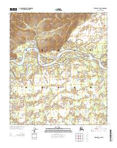
2013 Map of Fairbanks C-4 SW
USGS Topo · Published 2013About this map
The Tanana River dominates this portion of the interior, winding through a complex network of braided channels and sandbars north of the Tatatlanika River confluence. This 2013 survey illustrates the dynamic nature of the Alaskan wilderness, where the shifting waters define the landscape far more than any permanent settlement. The northern bank is characterized by steep, rising relief, contrasting sharply with the marshy, low-lying wetlands that spread across the southern half of the quadrangle. While modern geospatial data from the U.S. Geological Survey and the Bureau of Land Management provide the technical framework, the map primarily serves as a detailed record of water drainage and terrain in an area devoid of roads or named human structures.
Find a feature on this map
5 named features on this map. Tap any name to fly to it.
Don’t see what you’re looking for? This feature index may not catch every label — zoom into the map to look around manually.
Map Details
Editions of this 2013 Fairbanks C-4 SW Map
This is the sole edition of this map. No revisions or reprints were ever made.
Other maps of this area

1949 · Fairbanks B-5
USGS Topo · 1:63,360

1949 · Fairbanks B-4
USGS Topo · 1:63,360

1950 · Fairbanks
USGS Topo · 1:250,000

1950 · Fairbanks C-5
USGS Topo · 1:63,360

1950 · Fairbanks C-4
USGS Topo · 1:63,360

1950 · Fairbanks B-5
USGS Topo · 1:63,360

1951 · Fairbanks B-5
USGS Topo · 1:63,360

1951 · Fairbanks
USGS Topo · 1:250,000

1952 · Fairbanks C-4
USGS Topo · 1:63,360
1952 · Fairbanks B-4
USGS Topo · 1:63,360