
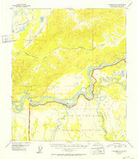
1952 Map of Fairbanks C-4
USGS Topo · Published 1952About this map
The Tanana River dominates the central corridor of this Alaskan landscape, serving as a defining boundary for the massive Ladd Air Force Base Military Reservation. This 1952 edition illustrates the post-war strategic importance of the region, featuring a designated Bombing and Gunnery Range south of the river. The infrastructure of the era is represented by The Alaska Railroad cutting through the northwestern corner near Twomile Lake, while an old Sled Road further north hints at traditional winter transport routes used before extensive modern highway development. Low-lying wetlands and complex river systems are evident as the Wood River and Tatlanika Creek converge with the Tanana. Occasional Cabin sites along the riverbanks indicate small-scale human presence in an otherwise government-and-military-oriented landscape.
Find a feature on this map
11 named features on this map. Tap any name to fly to it.
Don’t see what you’re looking for? This feature index may not catch every label — zoom into the map to look around manually.
Map Details
Editions of this 1952 Fairbanks C-4 Map
2 editions found
Other maps of this area

1949 · Fairbanks B-5
USGS Topo · 1:63,360

1949 · Fairbanks D-3
USGS Topo · 1:63,360

1949 · Fairbanks D-4
USGS Topo · 1:63,360

1949 · Fairbanks B-4
USGS Topo · 1:63,360

1949 · Fairbanks B-3
USGS Topo · 1:63,360

1950 · Fairbanks
USGS Topo · 1:250,000

1950 · Fairbanks C-3
USGS Topo · 1:63,360

1950 · Fairbanks C-5
USGS Topo · 1:63,360

1950 · Fairbanks C-4
USGS Topo · 1:63,360

1950 · Fairbanks D-5
USGS Topo · 1:63,360