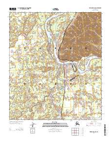
2013 Map of Fairbanks C-5 SE
USGS Topo · Published 2013About this map
Nenana sits at a critical hydrologic junction where the Nenana River flows into the braided channels of the Tanana River. This 2013 survey captures the settlement's infrastructure, including the Nenana Municipal Airport and a grid of streets from 1st St to 10th St. Across the water, North Nenana lies at the base of Mahon hill, illustrating the area's development along the higher ground of the northern bank.
Find a feature on this map
34 named features on this map. Tap any name to fly to it.
Don’t see what you’re looking for? This feature index may not catch every label — zoom into the map to look around manually.
Map Details
Editions of this 2013 Fairbanks C-5 SE Map
This is the sole edition of this map. No revisions or reprints were ever made.
Other maps of this area

1949 · Fairbanks B-5
USGS Topo · 1:63,360

1949 · Fairbanks B-4
USGS Topo · 1:63,360

1950 · Fairbanks
USGS Topo · 1:250,000

1950 · Fairbanks C-5
USGS Topo · 1:63,360

1950 · Fairbanks C-4
USGS Topo · 1:63,360

1950 · Fairbanks B-5
USGS Topo · 1:63,360

1951 · Fairbanks B-5
USGS Topo · 1:63,360

1951 · Fairbanks
USGS Topo · 1:250,000

1952 · Fairbanks C-4
USGS Topo · 1:63,360
1952 · Fairbanks B-4
USGS Topo · 1:63,360