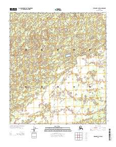
2013 Map of Fairbanks C-5 SW
USGS Topo · Published 2013About this map
The interior Alaskan landscape south of the W Middle River is defined by a complex network of small lakes, ponds, and wetlands within the Yukon-Koyukuk region. In this largely roadless territory, a single Sled Rd provides a vital land-based corridor across the southern townships, reflecting the essential role of winter transport routes in accessing the state's remote wilderness. The map details the transition across the public land survey boundaries of Townships 3, 4, and 5 South, where the terrain is almost entirely dominated by hydrologic features rather than permanent human settlements.
Find a feature on this map
5 named features on this map. Tap any name to fly to it.
Don’t see what you’re looking for? This feature index may not catch every label — zoom into the map to look around manually.
Map Details
Editions of this 2013 Fairbanks C-5 SW Map
This is the sole edition of this map. No revisions or reprints were ever made.
Other maps of this area

1949 · Fairbanks B-5
USGS Topo · 1:63,360

1950 · Fairbanks
USGS Topo · 1:250,000

1950 · Fairbanks C-5
USGS Topo · 1:63,360

1950 · Fairbanks B-5
USGS Topo · 1:63,360

1951 · Fairbanks B-5
USGS Topo · 1:63,360

1951 · Fairbanks
USGS Topo · 1:250,000
1952 · Fairbanks C-5
USGS Topo · 1:63,360

1952 · Fairbanks
USGS Topo · 1:250,000
1953 · Fairbanks C-6
USGS Topo · 1:63,360
1953 · Fairbanks B-6
USGS Topo · 1:63,360