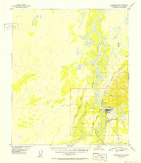
1952 Map of Fairbanks C-5
USGS Topo · Published 1952About this map
The confluence of the Tanana River and the Nenana River dominates this 1952 topographic survey, highlighting a critical transportation hub in the Alaska interior. The town of Nenana is the focal point, situated where The Alaska Railroad crosses the water, supported by the Nenana Airfield and a nearby airway beacon. This infrastructure illustrates the town's role as a vital transshipment point between rail and river traffic during the mid-century era.
Find a feature on this map
18 named features on this map. Tap any name to fly to it.
Don’t see what you’re looking for? This feature index may not catch every label — zoom into the map to look around manually.
Map Details
Editions of this 1952 Fairbanks C-5 Map
2 editions found
Other maps of this area

1949 · Fairbanks B-5
USGS Topo · 1:63,360

1949 · Fairbanks D-4
USGS Topo · 1:63,360

1949 · Fairbanks B-4
USGS Topo · 1:63,360

1950 · Fairbanks
USGS Topo · 1:250,000

1950 · Fairbanks C-5
USGS Topo · 1:63,360

1950 · Fairbanks C-4
USGS Topo · 1:63,360

1950 · Fairbanks D-5
USGS Topo · 1:63,360

1950 · Fairbanks B-5
USGS Topo · 1:63,360

1951 · Fairbanks B-5
USGS Topo · 1:63,360

1951 · Fairbanks
USGS Topo · 1:250,000