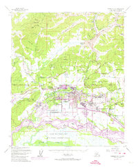
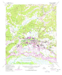
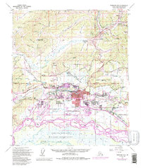
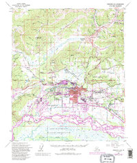
1954 Map of Fairbanks D-2
USGS Topo · Published 1974About this map
Fairbanks and its surrounding gold-rush territory are documented here during a period of significant mid-century expansion. The urban core near the Chena River is surrounded by established neighborhoods like Hamilton Acres and Lemeta, while the University of Alaska serves as an anchor to the west. Industrial and transport infrastructure is dense, featuring the Alaska Railroad and the Fairbanks International Airport. To the east, the sprawling Fort Wainwright military footprint is a dominant presence, illustrating the region's importance to national defense during the Cold War.
Find a feature on this map
91 named features on this map. Tap any name to fly to it.
Don’t see what you’re looking for? This feature index may not catch every label — zoom into the map to look around manually.
Map Details
Editions of this 1954 Fairbanks D-2 Map
5 editions found
Historical Maps of Fairbanks Through Time
340 maps found

1949 Big Delta B-5
Fairbanks North Star Borough, AK

1949 Big Delta B-6
Fairbanks North Star Borough, AK

1949 Big Delta C-6
Fairbanks North Star Borough, AK

1949 Fairbanks C-1
Fairbanks North Star Borough, AK

1949 Fairbanks C-2
Fairbanks North Star Borough, AK

1949 Fairbanks D-1
Fairbanks North Star Borough, AK

1949 Fairbanks D-2
Fairbanks North Star Borough, AK

1949 Fairbanks D-3
Fairbanks North Star Borough, AK

1950 Big Delta D-6
Fairbanks North Star Borough, AK

1950 Fairbanks B-1
Fairbanks North Star Borough, AK

1950 Fairbanks B-2
Fairbanks North Star Borough, AK

1950 Fairbanks C-1
Fairbanks North Star Borough, AK

1950 Fairbanks C-3
Fairbanks North Star Borough, AK

1950 Fairbanks D-3
Fairbanks North Star Borough, AK

1951 Circle A-5
Fairbanks North Star Borough, AK

1951 Fairbanks B-1
Fairbanks North Star Borough, AK

1951 Fairbanks B-2
Fairbanks North Star Borough, AK

1952 Big Delta B-5
Fairbanks North Star Borough, AK

1952 Big Delta B-6
Fairbanks North Star Borough, AK

1952 Big Delta C-6
Fairbanks North Star Borough, AK

1952 Big Delta D-6
Fairbanks North Star Borough, AK

1952 Circle A-4
Fairbanks North Star Borough, AK

1952 Circle A-5
Fairbanks North Star Borough, AK

1952 Fairbanks C-1
Fairbanks North Star Borough, AK

1952 Fairbanks C-2
Fairbanks North Star Borough, AK

1952 Fairbanks C-3
Fairbanks North Star Borough, AK

1952 Fairbanks D-1
Fairbanks North Star Borough, AK

1952 Fairbanks D-2
Fairbanks North Star Borough, AK

1952 Fairbanks D-3
Fairbanks North Star Borough, AK

1952 Livengood A-1
Fairbanks North Star Borough, AK

1952 Livengood A-2
Fairbanks North Star Borough, AK

1953 Livengood A-3
Fairbanks North Star Borough, AK

1954 Circle A-5
Fairbanks North Star Borough, AK

1954 Circle A-6
Fairbanks North Star Borough, AK

1954 Circle B-5
Fairbanks North Star Borough, AK

1954 Fairbanks D-2
Fairbanks North Star Borough, AK

1954 Livengood A-1
Fairbanks North Star Borough, AK

1954 Livengood A-2
Fairbanks North Star Borough, AK

1955 Fairbanks D-2
Fairbanks North Star Borough, AK

1958 Big Delta C-2
Fairbanks North Star Borough, AK

1958 Big Delta C-3
Fairbanks North Star Borough, AK

1958 Big Delta C-4
Fairbanks North Star Borough, AK

1958 Big Delta C-5
Fairbanks North Star Borough, AK

1958 Big Delta D-1
Fairbanks North Star Borough, AK

1958 Big Delta D-2
Fairbanks North Star Borough, AK

1958 Big Delta D-3
Fairbanks North Star Borough, AK

1958 Big Delta D-4
Fairbanks North Star Borough, AK

1958 Big Delta D-5
Fairbanks North Star Borough, AK

1965 Fairbanks D-2
Fairbanks North Star Borough, AK

1966 Fairbanks D-1 SW
Fairbanks North Star Borough, AK

1966 Fairbanks D-2 NE
Fairbanks North Star Borough, AK

1966 Fairbanks D-2 NW
Fairbanks North Star Borough, AK

1966 Fairbanks D-2 SE
Fairbanks North Star Borough, AK

1966 Fairbanks D-2 SW
Fairbanks North Star Borough, AK

1973 Big Delta D-3
Fairbanks North Star Borough, AK

1992 Big Delta B-6 NW
Fairbanks North Star Borough, AK

1992 Big Delta C-6 NW
Fairbanks North Star Borough, AK

1992 Big Delta C-6 SW
Fairbanks North Star Borough, AK

1992 Big Delta D-6 NW
Fairbanks North Star Borough, AK

1992 Big Delta D-6 SW
Fairbanks North Star Borough, AK

1992 Fairbanks C-1 NE
Fairbanks North Star Borough, AK

1992 Fairbanks C-1 NW
Fairbanks North Star Borough, AK

1992 Fairbanks C-1 SE
Fairbanks North Star Borough, AK

1992 Fairbanks D-1 NE
Fairbanks North Star Borough, AK

1992 Fairbanks D-1 NW
Fairbanks North Star Borough, AK

1992 Fairbanks D-1 SE
Fairbanks North Star Borough, AK

1992 Fairbanks D-1 SW
Fairbanks North Star Borough, AK

1992 Fairbanks D-2 NE
Fairbanks North Star Borough, AK

1992 Fairbanks D-2 NW
Fairbanks North Star Borough, AK

1992 Fairbanks D-2 SE
Fairbanks North Star Borough, AK

1992 Fairbanks D-2 SW
Fairbanks North Star Borough, AK

1992 Fairbanks D-3 NE
Fairbanks North Star Borough, AK

1992 Fairbanks D-3 SE
Fairbanks North Star Borough, AK

1992 Fairbanks D-3 SW
Fairbanks North Star Borough, AK

1992 Livengood A-1 SE
Fairbanks North Star Borough, AK

1992 Livengood A-1 SW
Fairbanks North Star Borough, AK

1992 Livengood A-2 SE
Fairbanks North Star Borough, AK

2013 Big Delta B-6 NW
Fairbanks North Star Borough, AK

2013 Big Delta B-6 SW
Fairbanks North Star Borough, AK

2013 Fairbanks B-1 NE
Fairbanks North Star Borough, AK

2013 Fairbanks B-1 NW
Fairbanks North Star Borough, AK

2013 Fairbanks B-1 SE
Fairbanks North Star Borough, AK

2013 Fairbanks B-1 SW
Fairbanks North Star Borough, AK

2013 Fairbanks B-2 NE
Fairbanks North Star Borough, AK

2013 Fairbanks B-2 NW
Fairbanks North Star Borough, AK

2013 Fairbanks B-2 SE
Fairbanks North Star Borough, AK

2013 Fairbanks B-2 SW
Fairbanks North Star Borough, AK

2013 Fairbanks B-3 NE
Fairbanks North Star Borough, AK

2013 Fairbanks C-2 NE
Fairbanks North Star Borough, AK

2013 Fairbanks C-2 NW
Fairbanks North Star Borough, AK

2013 Fairbanks C-2 SE
Fairbanks North Star Borough, AK

2013 Fairbanks C-2 SW
Fairbanks North Star Borough, AK

2013 Fairbanks C-3 NE
Fairbanks North Star Borough, AK

2013 Fairbanks C-3 NW
Fairbanks North Star Borough, AK

2013 Fairbanks C-3 SE
Fairbanks North Star Borough, AK

2013 Fairbanks C-3 SW
Fairbanks North Star Borough, AK

2013 Fairbanks D-2 NW
Fairbanks North Star Borough, AK

2013 Fairbanks D-2 SW
Fairbanks North Star Borough, AK

2013 Fairbanks D-3 NE
Fairbanks North Star Borough, AK

2013 Fairbanks D-3 NW
Fairbanks North Star Borough, AK

2013 Fairbanks D-3 SE
Fairbanks North Star Borough, AK

2013 Fairbanks D-3 SW
Fairbanks North Star Borough, AK

2016 Big Delta B-5 NE
Fairbanks North Star Borough, AK

2016 Big Delta B-5 NW
Fairbanks North Star Borough, AK

2016 Big Delta B-5 SW
Fairbanks North Star Borough, AK

2016 Big Delta B-6 NE
Fairbanks North Star Borough, AK

2016 Big Delta B-6 SE
Fairbanks North Star Borough, AK

2016 Big Delta C-3 NE
Fairbanks North Star Borough, AK

2016 Big Delta C-3 NW
Fairbanks North Star Borough, AK

2016 Big Delta C-3 SE
Fairbanks North Star Borough, AK

2016 Big Delta C-3 SW
Fairbanks North Star Borough, AK

2016 Big Delta C-4 NE
Fairbanks North Star Borough, AK

2016 Big Delta C-4 NW
Fairbanks North Star Borough, AK

2016 Big Delta C-4 SE
Fairbanks North Star Borough, AK

2016 Big Delta C-4 SW
Fairbanks North Star Borough, AK

2016 Big Delta C-5 NE
Fairbanks North Star Borough, AK

2016 Big Delta C-5 NW
Fairbanks North Star Borough, AK

2016 Big Delta C-5 SE
Fairbanks North Star Borough, AK

2016 Big Delta C-5 SW
Fairbanks North Star Borough, AK

2016 Big Delta C-6 NE
Fairbanks North Star Borough, AK

2016 Big Delta C-6 NW
Fairbanks North Star Borough, AK

2016 Big Delta C-6 SE
Fairbanks North Star Borough, AK

2016 Big Delta C-6 SW
Fairbanks North Star Borough, AK

2016 Big Delta D-3 NE
Fairbanks North Star Borough, AK

2016 Big Delta D-3 NW
Fairbanks North Star Borough, AK

2016 Big Delta D-3 SE
Fairbanks North Star Borough, AK

2016 Big Delta D-3 SW
Fairbanks North Star Borough, AK

2016 Big Delta D-4 NE
Fairbanks North Star Borough, AK

2016 Big Delta D-4 NW
Fairbanks North Star Borough, AK

2016 Big Delta D-4 SE
Fairbanks North Star Borough, AK

2016 Big Delta D-4 SW
Fairbanks North Star Borough, AK

2016 Big Delta D-5 NE
Fairbanks North Star Borough, AK

2016 Big Delta D-5 NW
Fairbanks North Star Borough, AK

2016 Big Delta D-5 SE
Fairbanks North Star Borough, AK

2016 Big Delta D-5 SW
Fairbanks North Star Borough, AK

2016 Big Delta D-6 NE
Fairbanks North Star Borough, AK

2016 Big Delta D-6 NW
Fairbanks North Star Borough, AK

2016 Big Delta D-6 SE
Fairbanks North Star Borough, AK

2016 Big Delta D-6 SW
Fairbanks North Star Borough, AK

2016 Fairbanks C-1 NE
Fairbanks North Star Borough, AK

2016 Fairbanks C-1 NW
Fairbanks North Star Borough, AK

2016 Fairbanks C-1 SE
Fairbanks North Star Borough, AK

2016 Fairbanks C-1 SW
Fairbanks North Star Borough, AK

2016 Fairbanks D-1 NE
Fairbanks North Star Borough, AK

2016 Fairbanks D-1 NW
Fairbanks North Star Borough, AK

2016 Fairbanks D-1 SE
Fairbanks North Star Borough, AK

2016 Fairbanks D-1 SW
Fairbanks North Star Borough, AK

2017 Chandalar A-1 SW
Fairbanks North Star Borough, AK

2017 Fairbanks D-2 NE
Fairbanks North Star Borough, AK

2017 Fairbanks D-2 SE
Fairbanks North Star Borough, AK

2017 Livengood A-1 NE
Fairbanks North Star Borough, AK

2017 Livengood A-1 NW
Fairbanks North Star Borough, AK

2017 Livengood A-1 SW
Fairbanks North Star Borough, AK

2017 Livengood A-2 NE
Fairbanks North Star Borough, AK

2017 Livengood A-2 NW
Fairbanks North Star Borough, AK

2017 Livengood A-2 SE
Fairbanks North Star Borough, AK

2017 Livengood A-2 SW
Fairbanks North Star Borough, AK

2017 Livengood A-3 NE
Fairbanks North Star Borough, AK

2017 Livengood A-3 NW
Fairbanks North Star Borough, AK

2017 Livengood A-3 SE
Fairbanks North Star Borough, AK

2017 Livengood A-3 SW
Fairbanks North Star Borough, AK

2017 Livengood A-4 NE
Fairbanks North Star Borough, AK

2017 Livengood A-4 SE
Fairbanks North Star Borough, AK

2018 Big Delta C-1 NE
Fairbanks North Star Borough, AK

2018 Big Delta C-1 NW
Fairbanks North Star Borough, AK

2018 Big Delta C-2 NE
Fairbanks North Star Borough, AK

2018 Big Delta C-2 NW
Fairbanks North Star Borough, AK

2018 Big Delta D-1 NE
Fairbanks North Star Borough, AK

2018 Big Delta D-1 NW
Fairbanks North Star Borough, AK

2018 Big Delta D-1 SE
Fairbanks North Star Borough, AK

2018 Big Delta D-1 SW
Fairbanks North Star Borough, AK

2018 Big Delta D-2 NE
Fairbanks North Star Borough, AK

2018 Big Delta D-2 NW
Fairbanks North Star Borough, AK

2018 Big Delta D-2 SE
Fairbanks North Star Borough, AK

2018 Big Delta D-2 SW
Fairbanks North Star Borough, AK

2018 Charley River A-6 SW
Fairbanks North Star Borough, AK

2018 Circle A-1 SE
Fairbanks North Star Borough, AK

2018 Circle A-1 SW
Fairbanks North Star Borough, AK

2018 Circle A-2 SE
Fairbanks North Star Borough, AK

2018 Circle A-2 SW
Fairbanks North Star Borough, AK

2018 Circle A-3 SE
Fairbanks North Star Borough, AK

2018 Circle A-3 SW
Fairbanks North Star Borough, AK

2018 Circle A-4 NW
Fairbanks North Star Borough, AK

2018 Circle A-4 SW
Fairbanks North Star Borough, AK

2018 Circle A-5 NE
Fairbanks North Star Borough, AK

2018 Circle A-5 NW
Fairbanks North Star Borough, AK

2018 Circle A-5 SE
Fairbanks North Star Borough, AK

2018 Circle A-5 SW
Fairbanks North Star Borough, AK

2018 Circle A-6 NE
Fairbanks North Star Borough, AK

2018 Circle A-6 NW
Fairbanks North Star Borough, AK

2018 Circle A-6 SE
Fairbanks North Star Borough, AK

2018 Circle A-6 SW
Fairbanks North Star Borough, AK

2018 Circle B-5 NW
Fairbanks North Star Borough, AK

2018 Circle B-5 SW
Fairbanks North Star Borough, AK

2018 Circle B-6 NE
Fairbanks North Star Borough, AK

2018 Circle B-6 SE
Fairbanks North Star Borough, AK

2018 Livengood A-1 SE
Fairbanks North Star Borough, AK

2021 Big Delta B-5 SW
Fairbanks North Star Borough, AK

2021 Big Delta B-6 NE
Fairbanks North Star Borough, AK

2021 Big Delta B-6 NW
Fairbanks North Star Borough, AK

2021 Big Delta B-6 SE
Fairbanks North Star Borough, AK

2021 Big Delta B-6 SW
Fairbanks North Star Borough, AK

2021 Big Delta C-4 NE
Fairbanks North Star Borough, AK

2021 Big Delta C-4 NW
Fairbanks North Star Borough, AK

2021 Big Delta C-5 SE
Fairbanks North Star Borough, AK

2021 Big Delta C-5 SW
Fairbanks North Star Borough, AK

2021 Big Delta C-6 NW
Fairbanks North Star Borough, AK

2021 Big Delta C-6 SE
Fairbanks North Star Borough, AK

2021 Big Delta C-6 SW
Fairbanks North Star Borough, AK

2021 Big Delta D-5 NE
Fairbanks North Star Borough, AK

2021 Big Delta D-5 NW
Fairbanks North Star Borough, AK

2021 Big Delta D-6 NE
Fairbanks North Star Borough, AK

2021 Big Delta D-6 NW
Fairbanks North Star Borough, AK

2021 Big Delta D-6 SE
Fairbanks North Star Borough, AK

2021 Big Delta D-6 SW
Fairbanks North Star Borough, AK

2021 Circle A-5 SE
Fairbanks North Star Borough, AK

2021 Fairbanks B-1 NE
Fairbanks North Star Borough, AK

2021 Fairbanks C-1 NE
Fairbanks North Star Borough, AK

2021 Fairbanks C-1 NW
Fairbanks North Star Borough, AK

2021 Fairbanks C-1 SE
Fairbanks North Star Borough, AK

2021 Fairbanks C-3 NE
Fairbanks North Star Borough, AK

2021 Fairbanks C-3 NW
Fairbanks North Star Borough, AK

2021 Fairbanks D-1 NE
Fairbanks North Star Borough, AK

2021 Fairbanks D-1 NW
Fairbanks North Star Borough, AK

2021 Fairbanks D-1 SE
Fairbanks North Star Borough, AK

2021 Fairbanks D-1 SW
Fairbanks North Star Borough, AK

2021 Fairbanks D-2 NE
Fairbanks North Star Borough, AK

2021 Fairbanks D-2 NW
Fairbanks North Star Borough, AK

2021 Fairbanks D-2 SE
Fairbanks North Star Borough, AK

2021 Fairbanks D-2 SW
Fairbanks North Star Borough, AK

2021 Fairbanks D-3 NE
Fairbanks North Star Borough, AK

2021 Fairbanks D-3 NW
Fairbanks North Star Borough, AK

2021 Fairbanks D-3 SE
Fairbanks North Star Borough, AK

2021 Fairbanks D-3 SW
Fairbanks North Star Borough, AK

2021 Livengood A-1 NE
Fairbanks North Star Borough, AK

2021 Livengood A-1 NW
Fairbanks North Star Borough, AK

2021 Livengood A-1 SE
Fairbanks North Star Borough, AK

2021 Livengood A-1 SW
Fairbanks North Star Borough, AK

2021 Livengood A-2 NE
Fairbanks North Star Borough, AK

2021 Livengood A-2 NW
Fairbanks North Star Borough, AK

2021 Livengood A-2 SE
Fairbanks North Star Borough, AK

2021 Livengood A-2 SW
Fairbanks North Star Borough, AK

2021 Livengood A-3 NE
Fairbanks North Star Borough, AK

2021 Livengood A-3 SE
Fairbanks North Star Borough, AK

2021 Livengood A-3 SW
Fairbanks North Star Borough, AK

2024 Big Delta B-5 NE
Fairbanks North Star Borough, AK

2024 Big Delta B-5 NW
Fairbanks North Star Borough, AK

2024 Big Delta B-5 SW
Fairbanks North Star Borough, AK

2024 Big Delta B-6 NE
Fairbanks North Star Borough, AK

2024 Big Delta B-6 SE
Fairbanks North Star Borough, AK

2024 Big Delta C-1 NE
Fairbanks North Star Borough, AK

2024 Big Delta C-1 NW
Fairbanks North Star Borough, AK

2024 Big Delta C-2 NE
Fairbanks North Star Borough, AK

2024 Big Delta C-2 NW
Fairbanks North Star Borough, AK

2024 Big Delta C-3 NE
Fairbanks North Star Borough, AK

2024 Big Delta C-3 NW
Fairbanks North Star Borough, AK

2024 Big Delta C-3 SE
Fairbanks North Star Borough, AK

2024 Big Delta C-3 SW
Fairbanks North Star Borough, AK

2024 Big Delta C-4 NE
Fairbanks North Star Borough, AK

2024 Big Delta C-4 NW
Fairbanks North Star Borough, AK

2024 Big Delta C-4 SE
Fairbanks North Star Borough, AK

2024 Big Delta C-4 SW
Fairbanks North Star Borough, AK

2024 Big Delta C-5 NE
Fairbanks North Star Borough, AK

2024 Big Delta C-5 NW
Fairbanks North Star Borough, AK

2024 Big Delta C-5 SE
Fairbanks North Star Borough, AK

2024 Big Delta C-5 SW
Fairbanks North Star Borough, AK

2024 Big Delta C-6 NE
Fairbanks North Star Borough, AK

2024 Big Delta C-6 NW
Fairbanks North Star Borough, AK

2024 Big Delta C-6 SE
Fairbanks North Star Borough, AK

2024 Big Delta D-1 NE
Fairbanks North Star Borough, AK

2024 Big Delta D-1 NW
Fairbanks North Star Borough, AK

2024 Big Delta D-1 SE
Fairbanks North Star Borough, AK

2024 Big Delta D-1 SW
Fairbanks North Star Borough, AK

2024 Big Delta D-2 NE
Fairbanks North Star Borough, AK

2024 Big Delta D-2 NW
Fairbanks North Star Borough, AK

2024 Big Delta D-2 SE
Fairbanks North Star Borough, AK

2024 Big Delta D-2 SW
Fairbanks North Star Borough, AK

2024 Big Delta D-3 NE
Fairbanks North Star Borough, AK

2024 Big Delta D-3 NW
Fairbanks North Star Borough, AK

2024 Big Delta D-3 SE
Fairbanks North Star Borough, AK

2024 Big Delta D-3 SW
Fairbanks North Star Borough, AK

2024 Big Delta D-4 NE
Fairbanks North Star Borough, AK

2024 Big Delta D-4 NW
Fairbanks North Star Borough, AK

2024 Big Delta D-4 SE
Fairbanks North Star Borough, AK

2024 Big Delta D-4 SW
Fairbanks North Star Borough, AK

2024 Big Delta D-5 NE
Fairbanks North Star Borough, AK

2024 Big Delta D-5 NW
Fairbanks North Star Borough, AK

2024 Big Delta D-5 SE
Fairbanks North Star Borough, AK

2024 Big Delta D-5 SW
Fairbanks North Star Borough, AK

2024 Big Delta D-6 NE
Fairbanks North Star Borough, AK

2024 Big Delta D-6 NW
Fairbanks North Star Borough, AK

2024 Big Delta D-6 SE
Fairbanks North Star Borough, AK

2024 Big Delta D-6 SW
Fairbanks North Star Borough, AK

2024 Circle A-1 SE
Fairbanks North Star Borough, AK

2024 Circle A-1 SW
Fairbanks North Star Borough, AK

2024 Circle A-2 SE
Fairbanks North Star Borough, AK

2024 Circle A-2 SW
Fairbanks North Star Borough, AK

2024 Circle A-3 SE
Fairbanks North Star Borough, AK

2024 Circle A-3 SW
Fairbanks North Star Borough, AK

2024 Circle A-4 NW
Fairbanks North Star Borough, AK

2024 Circle A-4 SW
Fairbanks North Star Borough, AK

2024 Circle A-5 NE
Fairbanks North Star Borough, AK

2024 Circle A-5 NW
Fairbanks North Star Borough, AK

2024 Circle A-5 SE
Fairbanks North Star Borough, AK

2024 Circle A-5 SW
Fairbanks North Star Borough, AK

2024 Circle A-6 NE
Fairbanks North Star Borough, AK

2024 Circle A-6 NW
Fairbanks North Star Borough, AK

2024 Circle A-6 SE
Fairbanks North Star Borough, AK

2024 Circle A-6 SW
Fairbanks North Star Borough, AK

2024 Circle B-5 NW
Fairbanks North Star Borough, AK

2024 Circle B-5 SW
Fairbanks North Star Borough, AK

2024 Circle B-6 NE
Fairbanks North Star Borough, AK

2024 Circle B-6 SE
Fairbanks North Star Borough, AK

2024 Fairbanks C-3 NW
Fairbanks North Star Borough, AK

2024 Fairbanks D-1 NE
Fairbanks North Star Borough, AK

2024 Fairbanks D-1 NW
Fairbanks North Star Borough, AK

2024 Fairbanks D-1 SE
Fairbanks North Star Borough, AK

2024 Fairbanks D-1 SW
Fairbanks North Star Borough, AK

2024 Fairbanks D-2 NE
Fairbanks North Star Borough, AK

2024 Fairbanks D-2 NW
Fairbanks North Star Borough, AK

2024 Fairbanks D-2 SE
Fairbanks North Star Borough, AK

2024 Fairbanks D-2 SW
Fairbanks North Star Borough, AK

2024 Fairbanks D-3 NE
Fairbanks North Star Borough, AK

2024 Fairbanks D-3 NW
Fairbanks North Star Borough, AK

2024 Fairbanks D-3 SE
Fairbanks North Star Borough, AK

2024 Fairbanks D-3 SW
Fairbanks North Star Borough, AK

2024 Livengood A-1 NE
Fairbanks North Star Borough, AK

2024 Livengood A-1 NW
Fairbanks North Star Borough, AK

2024 Livengood A-1 SE
Fairbanks North Star Borough, AK

2024 Livengood A-1 SW
Fairbanks North Star Borough, AK

2024 Livengood A-2 NE
Fairbanks North Star Borough, AK

2024 Livengood A-2 NW
Fairbanks North Star Borough, AK

2024 Livengood A-2 SE
Fairbanks North Star Borough, AK

2024 Livengood A-2 SW
Fairbanks North Star Borough, AK

2024 Livengood A-3 NE
Fairbanks North Star Borough, AK

2024 Livengood A-3 NW
Fairbanks North Star Borough, AK

2024 Livengood A-3 SE
Fairbanks North Star Borough, AK

2024 Livengood A-3 SW
Fairbanks North Star Borough, AK

2024 Livengood A-4 NE
Fairbanks North Star Borough, AK

2024 Livengood A-4 SE
Fairbanks North Star Borough, AK