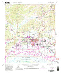
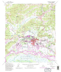
1954 Map of Fairbanks D-2
USGS Topo · Published 1995About this map
Chena River and Tanana River dominate this interior Alaska landscape, providing the hydrological framework for the development of Fairbanks and its surrounding communities. The map documents a period of significant mid-century growth, notably around the University of Alaska in College and the expansion of residential neighborhoods like Lemeta and Slaterville. The presence of the Alaska Railroad and major thoroughfares like the Steese Highway illustrates the transportation network that fueled the region's economy, while the The Trans-Alaska Pipeline corridor reflects later industrial development.
Find a feature on this map
82 named features on this map. Tap any name to fly to it.
Don’t see what you’re looking for? This feature index may not catch every label — zoom into the map to look around manually.
Map Details
Editions of this 1954 Fairbanks D-2 Map
5 editions found
Other maps of this area

1945 · Livengood
USGS Topo · 1:250,000

1949 · Fairbanks D-1
USGS Topo · 1:62,500

1949 · Fairbanks D-2
USGS Topo · 1:62,500

1949 · Fairbanks C-1
USGS Topo · 1:63,360

1949 · Fairbanks D-3
USGS Topo · 1:63,360

1949 · Fairbanks C-2
USGS Topo · 1:63,360

1950 · Fairbanks
USGS Topo · 1:250,000

1950 · Fairbanks C-3
USGS Topo · 1:63,360

1950 · Fairbanks C-1
USGS Topo · 1:63,360

1950 · Fairbanks D-3
USGS Topo · 1:63,360