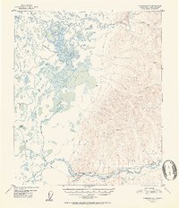
1952 Map of Fairbanks D-4
USGS Topo · Published 1952About this map
Minto Lakes and the sprawling wetland complex of Goldstream Creek dominate the western half of this interior Alaskan landscape, surveyed in the late 1940s. The terrain transitions abruptly from the labyrinthine waterways and marshes of the Tanana Valley to the high, ridged country in the east, marked by summits like VABM 2807 Luck. This map captures a remote section of the Alaska Railroad corridor, where the small station at Dunbar and the Section House at Mile 433 served the rail line as it skirted the southern edge of the hills. Local history is anchored by the Indian Cemetery near Beaver Dam Lake, while several isolated cabins and the Sled Road winding toward the Chatanika River illustrate the seasonal transportation networks essential for travel across the muskeg and hills before extensive highway development.
Find a feature on this map
17 named features on this map. Tap any name to fly to it.
Don’t see what you’re looking for? This feature index may not catch every label — zoom into the map to look around manually.
Map Details
Editions of this 1952 Fairbanks D-4 Map
2 editions found

Other maps of this area

1945 · Livengood
USGS Topo · 1:250,000

1949 · Fairbanks D-3
USGS Topo · 1:63,360

1949 · Fairbanks D-4
USGS Topo · 1:63,360

1950 · Fairbanks
USGS Topo · 1:250,000

1950 · Fairbanks C-3
USGS Topo · 1:63,360

1950 · Fairbanks C-5
USGS Topo · 1:63,360

1950 · Fairbanks C-4
USGS Topo · 1:63,360

1950 · Fairbanks D-5
USGS Topo · 1:63,360

1950 · Fairbanks D-3
USGS Topo · 1:63,360

1951 · Fairbanks
USGS Topo · 1:250,000