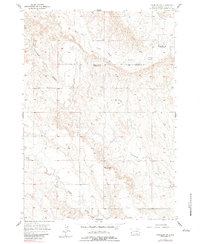
1957 Map of Fairburn SW
USGS Topo · Published 1983About this map
The South Fork French Creek and Cottonwood Creek carve through the high plains of Custer County in this mid-century topographic study. The landscape is defined by its drainage patterns and the sparse remnants of early ranching-era infrastructure. The most striking social detail is the presence of multiple defunct educational sites, including the South Fork Sch, Cottonwood Sch, and Hill View Sch. Their status as abandoned landmarks by the 1950s indicates a significant shift in rural population and the consolidation of rural school districts in the Black Hills region. In the southern portion of the quadrangle, the terrain transitions toward Lame Johnny Creek, showing a rugged network of draws and ridges that once supported these isolated homesteading communities.
Find a feature on this map
6 named features on this map. Tap any name to fly to it.
Don’t see what you’re looking for? This feature index may not catch every label — zoom into the map to look around manually.
Map Details
Editions of this 1957 Fairburn SW Map
2 editions found
Other maps of this area

1894 · Hermosa
USGS Topo · 1:125,000

1896 · Oelrichs
USGS Topo · 1:125,000

1900 · Oelrichs
USGS Topo · 1:125,000

1901 · Hermosa
USGS Topo · 1:125,000

1950 · Buffalo Gap
USGS Topo · 1:24,000

1951 · Fairburn SE
USGS Topo · 1:24,000

1951 · Smithwick NE
USGS Topo · 1:24,000

1951 · Smithwick NW
USGS Topo · 1:24,000

1955 · Hot Springs
USGS Topo · 1:250,000
1957 · Fairburn NE
USGS Topo · 1:24,000