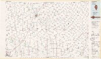
1985 Map of Fairbury
USGS Topo · Published 1985About this map
The Vermilion River and its numerous tributaries, including Rooks Creek and Wolf Creek, define the drainage and early settlement patterns of this central Illinois landscape. As of the mid-1980s, the region was a critical intersection of major rail lines, including the Illinois Central Gulf and the Atchison Topeka and Santa Fe, which linked farming hubs like Fairbury and Chatsworth to wider markets. The sprawling State Correctional Center near Pontiac stands as a significant landmark, while the southern reaches of the map show the headwaters of the Mackinaw River and the artificial waters of Lake Bloomington. A lone elevation at Blue Mound rises above the glacial plains, providing a rare break in the level terrain that supported the intensive agricultural development visible in the grid of rural roads and scattered grain-handling settlements like Saunemin and Forrest.
Find a feature on this map
108 named features on this map. Tap any name to fly to it.
Don’t see what you’re looking for? This feature index may not catch every label — zoom into the map to look around manually.
Map Details
Editions of this 1985 Fairbury Map
2 editions found
Other maps of this area

1922 · Kankakee
USGS Topo · 1:62,500

1923 · Herscher
USGS Topo · 1:62,500

1924 · Kankakee
USGS Topo · 1:62,500

1924 · Paxton
USGS Topo · 1:62,500

1925 · Herscher
USGS Topo · 1:62,500

1925 · Streator
USGS Topo · 1:62,500

1926 · Normal
USGS Topo · 1:62,500

1927 · Paxton
USGS Topo · 1:62,500

1927 · Streator
USGS Topo · 1:62,500

1927 · Danvers
USGS Topo · 1:62,500