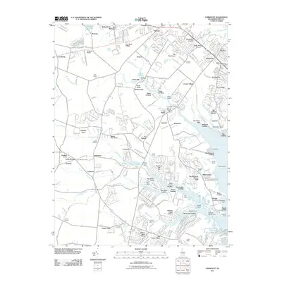
2011 Map of Fairmount
USGS Topo · Published 2011About this map
Goslee Mill and its associated Goslee Mill Pond Dam reflect the long history of milling in this coastal Delaware landscape. This 2011 survey shows a transition from traditional agricultural settlements like Robinsonville and Cool Spring toward modern residential developments along the inlets of Rehoboth Bay. The terrain is deeply articulated by tidal creeks and branches, including Love Creek, Guinea Creek, and Arnell Creek, which historically supported landings such as Fisher Landing and Robinson Landing. Genealogy researchers will find several notable burial grounds, including the Indian Mission Cemetery, Ebenezer Cemetery, and Saint Georges Cemetery. The presence of the Cool Spring Grange and Angola Grange underscores the area's social history rooted in its farming past, even as Long Neck and surrounding areas show increased urbanization through various named acres and villages.
Find a feature on this map
101 named features on this map. Tap any name to fly to it.
Don’t see what you’re looking for? This feature index may not catch every label — zoom into the map to look around manually.
Map Details
Editions of this 2011 Fairmount Map
This is the sole edition of this map. No revisions or reprints were ever made.
Other maps of this area

1917 · Millsboro
USGS Topo · 1:62,500

1918 · Cedar Creek
USGS Topo · 1:62,500

1918 · Rehoboth
USGS Topo · 1:62,500

1918 · Cape Henlopen
USGS Topo · 1:62,500

1919 · Cedar Creek
USGS Topo · 1:62,500

1937 · Cape Henlopen
USGS Topo · 1:62,500

1938 · Cedar Creek
USGS Topo · 1:62,500

1938 · Millsboro
USGS Topo · 1:62,500

1938 · Rehoboth
USGS Topo · 1:62,500

1943 · Fairmount
USGS Topo · 1:24,000