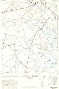
1948 Map of Fairmount
USGS Topo · Published 1949About this map
Rehoboth Bay and its intricate network of tidal creeks and marshes define the landscape of eastern Sussex County just after World War II. The map reveals a transition between the established agricultural interior and the emerging coastal infrastructure of the era, marked by the Rehoboth Airport and the Willowmer Seaplane Base. Inland, the economy is centered on small communities like Robinsonville and Fairmount, with local social life anchored by institutions such as the Cool Spring Grange, Nassau Sch, and the Harmony Church.
Find a feature on this map
95 named features on this map. Tap any name to fly to it.
Don’t see what you’re looking for? This feature index may not catch every label — zoom into the map to look around manually.
Map Details
Editions of this 1948 Fairmount Map
This is the sole edition of this map. No revisions or reprints were ever made.
Other maps of this area

1917 · Millsboro
USGS Topo · 1:62,500

1918 · Cedar Creek
USGS Topo · 1:62,500

1918 · Rehoboth
USGS Topo · 1:62,500

1918 · Cape Henlopen
USGS Topo · 1:62,500

1919 · Cedar Creek
USGS Topo · 1:62,500

1937 · Cape Henlopen
USGS Topo · 1:62,500

1938 · Cedar Creek
USGS Topo · 1:62,500

1938 · Millsboro
USGS Topo · 1:62,500

1938 · Rehoboth
USGS Topo · 1:62,500

1943 · Fairmount
USGS Topo · 1:24,000
Featured Places
- Angola Crest Mobile Home Park, DE
- Angola Landing, DE
- Cool Spring, DE
- William Ritter Manor, DE
- Mallard Point, DE