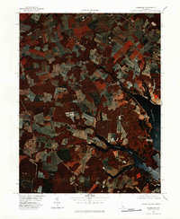
1980 Map of Fairmount
USGS Topo · Published 1982About this map
Agricultural fields and woodland patches define the landscape of Sussex County in this 1980 color infrared orthophotograph. The intricate shoreline of Rehoboth Bay dominates the eastern edge, where The Narrows connects tidal waters to a network of inland tributaries. Small crossroads settlements like Fairmount, Robinsonville, and Belltown are visible as clusters of structures amidst the geometric patterns of Delaware farmland.
Find a feature on this map
11 named features on this map. Tap any name to fly to it.
Don’t see what you’re looking for? This feature index may not catch every label — zoom into the map to look around manually.
Map Details
Editions of this 1980 Fairmount Map
This is the sole edition of this map. No revisions or reprints were ever made.
Other maps of this area

1917 · Millsboro
USGS Topo · 1:62,500

1918 · Cedar Creek
USGS Topo · 1:62,500

1918 · Rehoboth
USGS Topo · 1:62,500

1918 · Cape Henlopen
USGS Topo · 1:62,500

1919 · Cedar Creek
USGS Topo · 1:62,500

1937 · Cape Henlopen
USGS Topo · 1:62,500

1938 · Cedar Creek
USGS Topo · 1:62,500

1938 · Millsboro
USGS Topo · 1:62,500

1938 · Rehoboth
USGS Topo · 1:62,500

1943 · Fairmount
USGS Topo · 1:24,000
Featured Places
- Angola Crest Mobile Home Park, DE
- Angola Landing, DE
- Cool Spring, DE
- William Ritter Manor, DE
- Mallard Point, DE