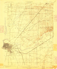
1902 Map of Fairoaks
USGS Topo · Published 1910About this map
Sacramento serves as the urban anchor for this early twentieth-century landscape, which captures the burgeoning neighborhoods of Oak Park and Highland Park alongside the historic land grant of New Helvetia. The rail infrastructure is particularly prominent, showing the Southern Pacific R. R. (Ogden Line) and the Placerville Branch radiating out toward agricultural and mining hubs. Along the banks of the American River, the map documents established waypoints like Twelvemile House and the namesake settlement of Fairoaks. The northern expanse of the Del Paso and San Juan regions is punctuated by small railroad stops and ranching stations such as Ben Ali, Antelope, and Salsbury, illustrating the transition from the capital's city grid to the rural foothills before the massive suburban expansion of the later century.
Find a feature on this map
39 named features on this map. Tap any name to fly to it.
Don’t see what you’re looking for? This feature index may not catch every label — zoom into the map to look around manually.
Map Details
Editions of this 1902 Fairoaks Map
2 editions found
Other maps of this area

1891 · Sacramento
USGS Topo · 1:125,000

1892 · Sacramento
USGS Topo · 1:125,000

1893 · Sacramento
USGS Topo · 1:125,000

1894 · Lodi
USGS Topo · 1:125,000

1902 · Fairoaks
USGS Topo · 1:62,500

1907 · Davisville
USGS Topo · 1:62,500

1908 · Courtland
USGS Topo · 1:62,500

1908 · Buffalo Creek
USGS Topo · 1:31,680

1909 · Elk Grove
USGS Topo · 1:31,680

1909 · Cosumnes
USGS Topo · 1:31,680