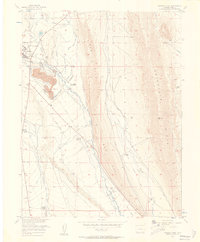
1956 Map of Fairplay East
USGS Topo · Published 1957About this map
The town of Fairplay and its immediate eastern surroundings in the mid-1950s reveal a landscape shaped by water engineering and mineral extraction. Large areas of tailings south of town, along with numerous gravel pits, point to the heavy industrial activity that defined the area's development. The hydrology is dominated by the Middle Fork South Platte River, which is fed and diverted by an extensive network of irrigation infrastructure, including the Weston Ditch, Anderson Ditch No 1, and the Miller-Chapman Ditch.
Find a feature on this map
32 named features on this map. Tap any name to fly to it.
Don’t see what you’re looking for? This feature index may not catch every label — zoom into the map to look around manually.
Map Details
Editions of this 1956 Fairplay East Map
3 editions found

Other maps of this area

1889 · Leadville
USGS Topo · 1:125,000

1891 · Leadville
USGS Topo · 1:125,000

1934 · Climax
USGS Topo · 1:48,000

1937 · Como
USGS Topo · 1:62,500

1938 · Mt. Lincoln
USGS Topo · 1:48,000

1942 · Leadville
USGS Topo · 1:125,000

1945 · Mount Lincoln
USGS Topo · 1:62,500

1953 · Denver
USGS Topo · 1:250,000

1956 · Elkhorn
USGS Topo · 1:24,000

1956 · Garo
USGS Topo · 1:24,000