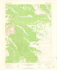
1960 Map of Fairplay West
USGS Topo · Published 1963About this map
The town of Fairplay sits at the eastern edge of this 1960s landscape, serving as a gateway to the high-altitude terrain of the Pike National Forest. This survey captures a transition in land use, documenting former active centers like Sacramento (Site) and Horseshoe (Site) that remain only as designated sites. The complex water management of the era is evident in the numerous channels branching from the Middle Fork South Platte River, including the Fairplay Mining Ditch, Westerman Ditch, and Columbia No 1 Ditch.
Find a feature on this map
41 named features on this map. Tap any name to fly to it.
Don’t see what you’re looking for? This feature index may not catch every label — zoom into the map to look around manually.
Map Details
Editions of this 1960 Fairplay West Map
4 editions found
Other maps of this area

1889 · Leadville
USGS Topo · 1:125,000

1891 · Leadville
USGS Topo · 1:125,000

1934 · Climax
USGS Topo · 1:48,000

1937 · Como
USGS Topo · 1:62,500

1938 · Mt. Lincoln
USGS Topo · 1:48,000

1942 · Leadville
USGS Topo · 1:125,000

1945 · Mount Lincoln
USGS Topo · 1:62,500

1953 · Denver
USGS Topo · 1:250,000

1956 · Garo
USGS Topo · 1:24,000

1956 · Fairplay East
USGS Topo · 1:24,000