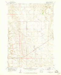
1959 Map of Fairpoint SE
USGS Topo · Published 1960About this map
East Elm Creek winds through this section of Meade County, defining a landscape primarily shaped by natural drainage and ranching activity. Surveyed in the late 1950s, the terrain shows a sparse settlement pattern characteristic of the western South Dakota plains. Aside from a small Gravel Pit near the eastern border, the area is notably devoid of heavy industrial development or concentrated towns, reflecting a quiet era of agricultural land use. A prominent landmark labeled C R O S S appears in the southwestern corner, while numerous benchmarks and elevation points indicate the systematic mapping of this high-plains topography. This document serves as a clear record of the rural landscape before modern rural development or intensive land-use changes altered the drainage basin of the Creek.
Find a feature on this map
4 named features on this map. Tap any name to fly to it.
Don’t see what you’re looking for? This feature index may not catch every label — zoom into the map to look around manually.
Map Details
Editions of this 1959 Fairpoint SE Map
2 editions found
Other maps of this area

1953 · Hereford
USGS Topo · 1:24,000

1953 · Hereford NE
USGS Topo · 1:24,000

1953 · Rapid City
USGS Topo · 1:250,000

1954 · Haydraw
USGS Topo · 1:24,000

1957 · Rapid City
USGS Topo · 1:250,000

1959 · Fairpoint
USGS Topo · 1:24,000

1959 · Fairpoint SW
USGS Topo · 1:24,000

1959 · Stoneville
USGS Topo · 1:24,000

1959 · Union Center
USGS Topo · 1:24,000

1959 · Fairpoint NW
USGS Topo · 1:24,000