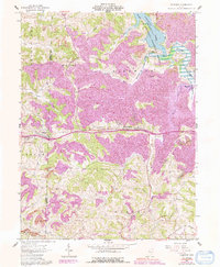
1961 Map of Fairview
USGS Topo · Published 1992About this map
The boundary between Guernsey Co and Belmont Co cuts through this landscape of deep-set valleys and industrial land use as it appeared in the early 1960s. The settlement of Fairview sits at the junction of Route 40, serving as a central point between Sewellsville to the north and the crossroads at Hendrysburg. Extensive extractive operations are evident across the terrain, with numerous Strip Mine sites and a prominent Lookout Tower overlooking the ridges near the Cabinet settlement.
Find a feature on this map
34 named features on this map. Tap any name to fly to it.
Don’t see what you’re looking for? This feature index may not catch every label — zoom into the map to look around manually.
Map Details
Editions of this 1961 Fairview Map
3 editions found
Other maps of this area

1903 · Flushing
USGS Topo · 1:62,500

1905 · Woodsfield
USGS Topo · 1:62,500

1905 · Flushing
USGS Topo · 1:62,500

1909 · Antrim
USGS Topo · 1:48,000

1909 · Summerfield
USGS Topo · 1:62,500

1911 · Antrim
USGS Topo · 1:62,500

1911 · Summerfield
USGS Topo · 1:62,500

1949 · Clarksburg
USGS Topo · 1:250,000

1951 · Canton
USGS Topo · 1:250,000

1953 · Canton
USGS Topo · 1:250,000