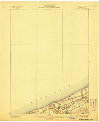
1900 Map of Fairview
USGS Topo · Published 1907About this map
The southern shoreline of Lake Erie defines this turn-of-the-century coastal landscape, where the transport corridor of Erie County, Pennsylvania, is densely packed with rival steam rail lines. The northern coast is dominated by the Lake Shore and Michigan Southern Railroad and the New York Chicago and St. Louis R. R., which run parallel toward the lake's edge. This rail-heavy infrastructure supported the growth of clustered settlements like Fairview, Avonia, and Miles Grove. Inland, the terrain is carved by the deep drainage of Elk Creek and Brandy Run, illustrating the challenges engineers faced in bridging these steep ravines. Smaller hubs such as Wallace Junction and Girard Junction highlight the era's complex network of switching points and rail interchanges that linked the Great Lakes trade to the Pennsylvania interior.
Find a feature on this map
16 named features on this map. Tap any name to fly to it.
Don’t see what you’re looking for? This feature index may not catch every label — zoom into the map to look around manually.
Map Details
Editions of this 1900 Fairview Map
5 editions found
Other maps of this area

1899 · Erie
USGS Topo · 1:62,500

1900 · Girard
USGS Topo · 1:62,500

1900 · Erie
USGS Topo · 1:62,500

1900 · Fairview
USGS Topo · 1:62,500

1906 · Conneaut
USGS Topo · 1:62,500

1923 · Cambridge Springs
USGS Topo · 1:62,500

1925 · Cambridge Springs
USGS Topo · 1:62,500

1943 · Cambridge Springs
USGS Topo · 1:62,500

1950 · Cleveland
USGS Topo · 1:250,000

1950 · Erie
USGS Topo · 1:250,000