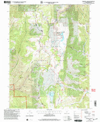
2001 Map of Fairview Lakes
USGS Topo · Published 2004About this map
Manti-La Sal National Forest dominates this high-elevation region of Sanpete County, where the 2001 revision illustrates a landscape defined by water management and mountain passage. The sheet centers on Fairview Lakes, supported by an Intake Gate and Gaging Station, alongside other vital reservoirs like the Lower Gooseberry Reservoir and Beaver Dam Reservoir. The drainage patterns are intricate, with numerous canyons such as Boulger Canyon and Flat Canyon feeding into the local creek systems. This era of the forest is characterized by recreation and transportation, notably the route of Skyline Drive and the Great Western Trail traversing the ridges. Scattered evidence of human activity appears at the Mammoth and Corral sites, while the Organization Site near Little Swens Canyon and a Scenic Overlook reflect the area's development for managed public access and utility.
Find a feature on this map
52 named features on this map. Tap any name to fly to it.
Don’t see what you’re looking for? This feature index may not catch every label — zoom into the map to look around manually.
Map Details
Editions of this 2001 Fairview Lakes Map
This is the sole edition of this map. No revisions or reprints were ever made.
Other maps of this area

1885 · Manti
USGS Topo · 1:250,000

1895 · Manti
USGS Topo · 1:250,000

1923 · Scofield
USGS Topo · 1:62,500

1925 · Scofield
USGS Topo · 1:62,500

1939 · Soldier Summit
USGS Topo · 1:62,500

1942 · Soldier Summit
USGS Topo · 1:62,500

1956 · Price
USGS Topo · 1:250,000

1960 · Price
USGS Topo · 1:250,000

1962 · Price
USGS Topo · 1:250,000

1965 · Huntington Reservoir
USGS Topo · 1:24,000