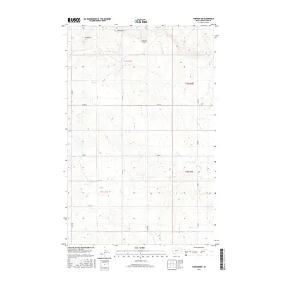
2017 Map of Fairview NW
USGS Topo · Published 2017About this map
Antelope Butte rises above the drainage networks of Richland County, defining the high ground in this section of the Montana prairie. This landscape is marked by a series of prominent coulees and seasonal watercourses, including Sheep Camp Coulee and Benson Coulee, which channel toward the N Fork Fourmile Cr in the northeast. The map provides a clear look at the rural section line road system, including Co RD 351 and Co RD 142, which link the scattered agricultural holdings. A significant point of interest for local history is the Fourmile Cem, situated along the eastern edge of the quadrangle. The southern portion of the sheet is characterized by the branching paths of Second Hay Cr and Third Hay Cr, illustrating the complex natural irrigation of the Missouri River watershed in this region.
Find a feature on this map
21 named features on this map. Tap any name to fly to it.
Don’t see what you’re looking for? This feature index may not catch every label — zoom into the map to look around manually.
Map Details
Editions of this 2017 Fairview NW Map
This is the sole edition of this map. No revisions or reprints were ever made.
Other maps of this area

1909 · Glendive
USGS Topo · 1:250,000

1954 · Glendive
USGS Topo · 1:250,000

1954 · Wolf Point
USGS Topo · 1:250,000

1957 · Glendive
USGS Topo · 1:250,000

1958 · Wolf Point
USGS Topo · 1:250,000

1958 · Glendive
USGS Topo · 1:250,000
1968 · Dore
USGS Topo · 1:24,000

1968 · Bainville SE
USGS Topo · 1:24,000

1969 · Cedar Coulee
USGS Topo · 1:24,000

1969 · Bainville SW
USGS Topo · 1:24,000