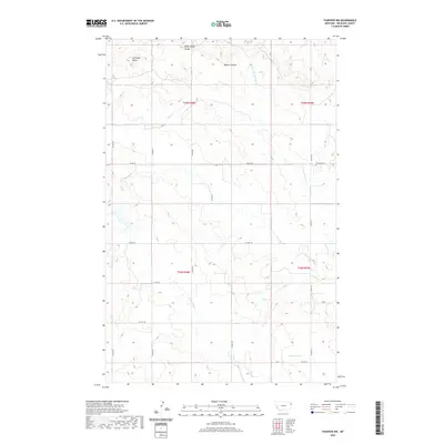
2020 Map of Fairview NW
USGS Topo · Published 2020About this map
Antelope Butte rises above the dissected rangeland of Richland County in this modern survey of the northeastern Montana plains. The landscape is defined by an intricate network of drainage coulees and seasonal creeks, including Sheep Camp Coulee and Benson Coulee, which carve through the high prairie. Human presence is marked primarily by the rectangular grid of the Public Land Survey System, with township boundaries like t26n r58e and t26n r59e organizing the vast open spaces.
Find a feature on this map
22 named features on this map. Tap any name to fly to it.
Don’t see what you’re looking for? This feature index may not catch every label — zoom into the map to look around manually.
Map Details
Editions of this 2020 Fairview NW Map
This is the sole edition of this map. No revisions or reprints were ever made.
Other maps of this area

1909 · Glendive
USGS Topo · 1:250,000

1954 · Glendive
USGS Topo · 1:250,000

1954 · Wolf Point
USGS Topo · 1:250,000

1957 · Glendive
USGS Topo · 1:250,000

1958 · Wolf Point
USGS Topo · 1:250,000

1958 · Glendive
USGS Topo · 1:250,000
1968 · Dore
USGS Topo · 1:24,000

1968 · Bainville SE
USGS Topo · 1:24,000

1969 · Cedar Coulee
USGS Topo · 1:24,000

1969 · Bainville SW
USGS Topo · 1:24,000