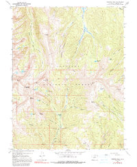
1967 Map of Fairview Peak
USGS Topo · Published 1991About this map
Gunnison National Forest preserves a landscape of sharp vertical relief and high-altitude basins as they appeared in the late 1960s. The map centers on a series of distinct peaks including Fairview Peak, Square Top Mountain, and Terrible Mountain, which overlook a network of alpine lakes such as Henry Lake and the Lower Lamphier Lake. The presence of the Fairview Mine, Sandy Hook Mine, and Gold Link Mine along the lower drainages of Gold Creek reflects the region's enduring mining heritage. Movement through this wilderness is defined by established routes like the Gunsight Trail and Boulder Trail, which navigate through gaps like Gunsight Pass and along the formidable spine of Fossil Ridge. This survey documents the intersection of recreational space, seen at the Gold Creek Campground, with the older industrial footprint of the gold-bearing gulches.
Find a feature on this map
50 named features on this map. Tap any name to fly to it.
Don’t see what you’re looking for? This feature index may not catch every label — zoom into the map to look around manually.
Map Details
Editions of this 1967 Fairview Peak Map
4 editions found
Other maps of this area

1934 · Taylor Park
USGS Topo · 1:62,500

1937 · Taylor Park
USGS Topo · 1:62,500

1940 · Garfield
USGS Topo · 1:62,500

1941 · Pitkin
USGS Topo · 1:62,500

1945 · Pitkin
USGS Topo · 1:62,500

1945 · Garfield
USGS Topo · 1:62,500

1955 · Mount Harvard
USGS Topo · 1:62,500

1956 · Montrose
USGS Topo · 1:250,000

1959 · Montrose
USGS Topo · 1:250,000

1960 · Montrose
USGS Topo · 1:250,000