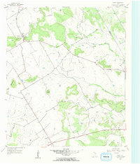
1956 Map of Fairy
USGS Topo · Published 1957About this map
The unincorporated community of Fairy sits at the northern edge of the Hamilton County hills, where local roads converge near the Fairy Cem and Martin Gap. This mid-1950s survey captures a landscape defined by ranching and small rural outposts, such as the small settlement of Lanham near the southern boundary. The terrain is notably marked by isolated peaks and promontories, including the Twin Mountains and Lone Mountain, which rise distinctly above the drainage basins of Meridian Creek and Sycamore Creek. Local landmarks like the Agee Ch and several named heights such as Paul Mountain and Stroud Mountain illustrate the family-centered geography of the era. The presence of a Gravel Pit and a major cross-country Pipeline near the Bosque County line indicates the small-scale industrial and utility infrastructure supporting the region during the post-war period.
Find a feature on this map
22 named features on this map. Tap any name to fly to it.
Don’t see what you’re looking for? This feature index may not catch every label — zoom into the map to look around manually.
Map Details
Editions of this 1956 Fairy Map
2 editions found
Other maps of this area

1888 · Hamilton
USGS Topo · 1:125,000

1888 · Meridian
USGS Topo · 1:125,000

1894 · Hamilton
USGS Topo · 1:125,000

1894 · Meridian
USGS Topo · 1:125,000

1954 · Brownwood
USGS Topo · 1:250,000

1954 · Waco
USGS Topo · 1:250,000

1955 · Waco
USGS Topo · 1:250,000

1956 · Cranfills Gap
USGS Topo · 1:24,000
1956 · German Valley
USGS Topo · 1:24,000

1956 · Hico
USGS Topo · 1:62,500