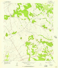
1956 Map of Fairy
USGS Topo · Published 1957About this map
The small settlement of Fairy serves as a primary landmark in this mid-1950s survey of the central Texas uplands. Located along the county line between Bosque Co and Hamilton Co, the area is defined by the headwaters of the Meridian Creek system and its various prongs. Local life is anchored by landmarks such as the Agee Ch and the Fairy Cem, while the landscape is punctuated by isolated elevations including Stroud Mountain, Paul Mountain, and the Twin Mountains. The rural character of the region is evident in the scattered communities of Lanham and Roberts, connected by a network of unimproved roads and light-duty paths. A Gravel Pit near the southern edge of the map indicates small-scale industrial activity alongside the traditional ranching and farming uses of the terrain near Sycamore Creek.
Find a feature on this map
20 named features on this map. Tap any name to fly to it.
Don’t see what you’re looking for? This feature index may not catch every label — zoom into the map to look around manually.
Map Details
Editions of this 1956 Fairy Map
2 editions found
Other maps of this area

1888 · Hamilton
USGS Topo · 1:125,000

1888 · Meridian
USGS Topo · 1:125,000

1894 · Hamilton
USGS Topo · 1:125,000

1894 · Meridian
USGS Topo · 1:125,000

1954 · Brownwood
USGS Topo · 1:250,000

1954 · Waco
USGS Topo · 1:250,000

1955 · Waco
USGS Topo · 1:250,000

1956 · Cranfills Gap
USGS Topo · 1:24,000
1956 · German Valley
USGS Topo · 1:24,000

1956 · Hico
USGS Topo · 1:62,500