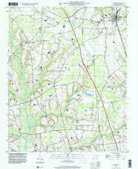
1997 Map of Faison
USGS Topo · Published 2000About this map
Faison sits at the northeastern corner of this late-20th-century landscape, positioned near the Sampson and Duplin County line. The map reveals an area defined by its intricate hydrology, where Tenmile Swamp, Mill Swamp, and Gilmore Swamp converge to feed into the larger Six Runs Creek system. These slow-moving water bodies dominate the western and southern reaches, while the agricultural and residential development remains concentrated along the higher ground and major road corridors, such as near Interchange 356.
Find a feature on this map
33 named features on this map. Tap any name to fly to it.
Don’t see what you’re looking for? This feature index may not catch every label — zoom into the map to look around manually.
Map Details
Editions of this 1997 Faison Map
This is the sole edition of this map. No revisions or reprints were ever made.
Other maps of this area

1909 · Coharie
USGS Topo · 1:62,500

1953 · Florence
USGS Topo · 1:250,000

1953 · Raleigh
USGS Topo · 1:250,000

1954 · Florence
USGS Topo · 1:250,000

1954 · Raleigh
USGS Topo · 1:250,000

1959 · Garland
USGS Topo · 1:62,500

1962 · Rose Hill
USGS Topo · 1:62,500

1975 · Faison
USGS Topo · 1:24,000
1977 · Warsaw North
USGS Topo · 1:24,000
1977 · Mount Olive
USGS Topo · 1:24,000