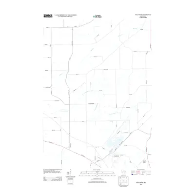
2013 Map of Fall River
USGS Topo · Published 2013About this map
Fall River and the smaller settlement of Englewood anchor this part of Columbia County, where the landscape is defined by the winding course of the N Br Crawfish River. The village of Fall River sits at the southern edge of Lazy Lake, a significant water body created by the widening of the river system. This 2013 survey illustrates a classic Wisconsin dairy country layout, where a dense network of local roads such as Mickelson Rd and Swarthout Rd connect outlying farmsteads to the central village. Notable transportation corridors include State Road 16 and State Road 146, which intersect near the village center. To the southeast, the Fountain Prairie Airport serves as a modern landmark, while the northern terrain is drained by Beaver Cr, flowing through a patchwork of agricultural fields and rural residential parcels identified by family-named routes like Pete Reak Rd.
Find a feature on this map
54 named features on this map. Tap any name to fly to it.
Don’t see what you’re looking for? This feature index may not catch every label — zoom into the map to look around manually.
Map Details
Editions of this 2013 Fall River Map
This is the sole edition of this map. No revisions or reprints were ever made.
Other maps of this area

1955 · Randolph
USGS Topo · 1:62,500

1955 · Columbus
USGS Topo · 1:62,500

1955 · Beaver Dam
USGS Topo · 1:62,500

1955 · Fox Lake
USGS Topo · 1:62,500

1957 · Madison
USGS Topo · 1:250,000

1960 · Madison
USGS Topo · 1:250,000

1980 · Fond Du Lac
USGS Topo · 1:100,000
1980 · North Bristol
USGS Topo · 1:24,000

1980 · Lost Lake
USGS Topo · 1:24,000
1980 · Columbus
USGS Topo · 1:24,000