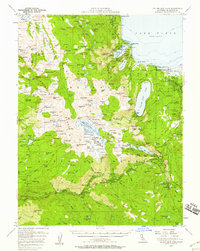
1955 Map of Fallen Leaf Lake
USGS Topo · Published 1958About this map
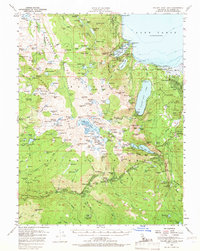
Emerald Bay State Park and the rugged southwestern shores of Lake Tahoe define this mid-century survey. The landscape is dotted with early resort and recreational infrastructure, including Tallac Village, Camp Richardson, and several organizational retreats such as the Berkeley Municipal Camp and Camp Sacramento. In the high country to the west, the map details the vast wilderness of the Eldorado National Forest, revealing a network of alpine lakes like Lake Schmidell and Wrights Lake before modern road expansions altered the backcountry access.
Find a feature on this map
205 named features on this map. Tap any name to fly to it.
Don’t see what you’re looking for? This feature index may not catch every label — zoom into the map to look around manually.
Map Details
Editions of this 1955 Fallen Leaf Lake Map
7 editions found
Other maps of this area

1889 · Pyramid Peak
USGS Topo · 1:125,000

1889 · Markleeville
USGS Topo · 1:125,000

1891 · Carson
USGS Topo · 1:125,000

1891 · Markleeville
USGS Topo · 1:125,000

1891 · Truckee
USGS Topo · 1:125,000

1891 · Pyramid Peak
USGS Topo · 1:125,000

1893 · Carson
USGS Topo · 1:125,000

1893 · Markleeville
USGS Topo · 1:125,000

1893 · Truckee
USGS Topo · 1:125,000

1895 · Pyramid Peak
USGS Topo · 1:125,000