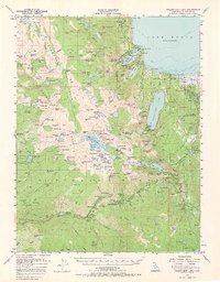
1955 Map of Fallen Leaf Lake
USGS Topo · Published 1966About this map
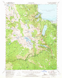
Emerald Bay State Park and the surrounding Sierra Nevada highlands are captured here in a mid-century period of recreation and rugged solitude. Along the western shores of Lake Tahoe, landmarks like the Vikingholm estate and Fannette I sit near D L Bliss State Park, while the interior reveals the primitive landscape of the Desolation Valley Wild Area. The map documents a transition from established resort hubs like Camp Richardson and Tallac Village to the high-country isolation of the Crystal Range. Cultural history is noted at Lyons (Site) and the Celio Ranch, while the era's reliance on mountain travel is seen in the Red Peak Trail and the emerging settlement at Tahoe Valley. This topography highlights the sheer density of alpine water bodies, from Fallen Leaf lake to the cluster of Grouse Lakes and Leland Lakes tucked beneath the granite peaks.
Find a feature on this map
208 named features on this map. Tap any name to fly to it.
Don’t see what you’re looking for? This feature index may not catch every label — zoom into the map to look around manually.
Map Details
Editions of this 1955 Fallen Leaf Lake Map
7 editions found
Other maps of this area

1889 · Pyramid Peak
USGS Topo · 1:125,000

1889 · Markleeville
USGS Topo · 1:125,000

1891 · Carson
USGS Topo · 1:125,000

1891 · Markleeville
USGS Topo · 1:125,000

1891 · Truckee
USGS Topo · 1:125,000

1891 · Pyramid Peak
USGS Topo · 1:125,000

1893 · Carson
USGS Topo · 1:125,000

1893 · Markleeville
USGS Topo · 1:125,000

1893 · Truckee
USGS Topo · 1:125,000

1895 · Pyramid Peak
USGS Topo · 1:125,000