
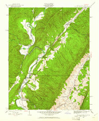
1929 Map of Falling Spring
USGS Topo · Published 1929About this map
The Jackson River carves a deep valley through the rugged Alleghany mountain landscape in this late 1920s survey. The map reveals a rural economy centered on the river and its tributaries, with Greavers Mill situated along the northern reaches and Smith Bridge crossing the water further south. Small mountain communities and hamlets like Tinkersville, Kinkaid, and Barber are clearly defined, showing the distribution of family homesteads and local infrastructure.
Find a feature on this map
30 named features on this map. Tap any name to fly to it.
Don’t see what you’re looking for? This feature index may not catch every label — zoom into the map to look around manually.
Map Details
Editions of this 1929 Falling Spring Map
2 editions found
Other maps of this area

1887 · Lewisburg
USGS Topo · 1:125,000

1891 · Lewisburg
USGS Topo · 1:125,000

1891 · Huntersville
USGS Topo · 1:125,000

1894 · Huntersville
USGS Topo · 1:125,000

1894 · Natural Bridge
USGS Topo · 1:125,000

1901 · Monterey
USGS Topo · 1:125,000

1921 · Callaghan
USGS Topo · 1:48,000

1923 · Marlinton
USGS Topo · 1:48,000

1923 · Warm Springs
USGS Topo · 1:48,000

1923 · Callaghan
USGS Topo · 1:62,500