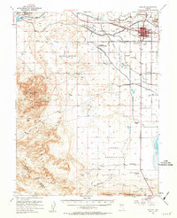
1951 Map of Fallon
USGS Topo · Published 1963About this map
Lahonton Valley irrigation systems define the landscape of the early 1950s, where a complex network of waterways like the U S Canal and Upper Diagonal Canal feed the agricultural lands surrounding Fallon. The town serves as a hub of early Nevada infrastructure, connected by the Southern Pacific railroad and anchored by the U S Experiment Station. Evidence of earlier eras remains visible through the Pony Express Route and the Pony Express Monument situated near the Deadman Mountains. The map reveals a transition in land use, noting an Island Sch (aban'd) and the Sheckler Reservoir (Aban'd), while the large Naval Reservation occupies the southeastern terrain. Rural life is marked by numerous country schools, including St Clair Sch and Lone Tree Sch, alongside the prominent Smith Ranch.
Find a feature on this map
48 named features on this map. Tap any name to fly to it.
Don’t see what you’re looking for? This feature index may not catch every label — zoom into the map to look around manually.
Map Details
Editions of this 1951 Fallon Map
3 editions found

Other maps of this area

1890 · Wadsworth
USGS Topo · 1:125,000

1891 · Wabuska
USGS Topo · 1:125,000

1892 · Wadsworth
USGS Topo · 1:125,000

1894 · Wadsworth
USGS Topo · 1:125,000

1894 · Wabuska
USGS Topo · 1:125,000

1908 · Carson Sink
USGS Topo · 1:250,000

1910 · Carson Sink
USGS Topo · 1:250,000

1950 · Stillwater
USGS Topo · 1:62,500

1951 · Carson Lake
USGS Topo · 1:62,500

1951 · Allen Springs
USGS Topo · 1:62,500