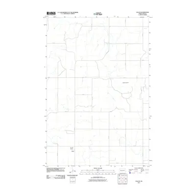
2011 Map of Fallon
USGS Topo · Published 2011About this map
Fallon is the central settlement in this portion of Morton County, marked by a sparse grid of rural roads and scattered homesteads. The landscape is defined by the high ground of Rattlesnake Hill and a series of intermittent drainage draws that carve through the prairie. Local history is anchored at the Saint Peter and Paul Cemetery, which serves as a significant genealogical marker for the community. A structured network of section-line roads, including 31st Ave and 60th St, facilitates travel across the agricultural terrain, while County Rd 83 provides a primary diagonal artery through the northern sections. This 2011 survey reflects the enduring rural character of the North Dakota plains, where small settlements like Fallon remain tied to the surrounding land and traditional community sites.
Find a feature on this map
19 named features on this map. Tap any name to fly to it.
Don’t see what you’re looking for? This feature index may not catch every label — zoom into the map to look around manually.
Map Details
Editions of this 2011 Fallon Map
This is the sole edition of this map. No revisions or reprints were ever made.
Other maps of this area

1907 · Bismarck
USGS Topo · 1:125,000

1954 · Bismarck
USGS Topo · 1:250,000

1958 · Bismarck
USGS Topo · 1:250,000

1979 · Bismarck
USGS Topo · 1:100,000

1980 · Breien
USGS Topo · 1:24,000

1980 · Fallon NE
USGS Topo · 1:24,000

1980 · Burgess
USGS Topo · 1:24,000
1980 · Linton
USGS Topo · 1:100,000
1980 · Lynwood
USGS Topo · 1:24,000
1980 · Saint Anthony
USGS Topo · 1:24,000