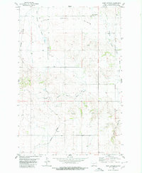
1980 Map of Saint Anthony
USGS Topo · Published 1980About this map
Saint Anthony sits at the northern edge of this high prairie landscape, anchoring a region defined by the drainage systems of the Little Heart Flats. The 1980 survey captures a period when the Burlington Northern railroad served as a primary transportation artery, running north-south through the western portion of the map and passing the small settlement of Inverlac. The terrain is characterized by the complex branching of the river system, including the South Branch Little Heart River and the Southeast Branch Little Heart River. Scattered agricultural infrastructure is visible throughout the quadrangle, evidenced by numerous wells and intermittent springs that supported the rural economy. The extensive system of fence lines, noted in the margin as fine red dashed lines, illustrates the organized land use and property boundaries essential to the local ranching and farming heritage of Morton County.
Find a feature on this map
12 named features on this map. Tap any name to fly to it.
Don’t see what you’re looking for? This feature index may not catch every label — zoom into the map to look around manually.
Map Details
Editions of this 1980 Saint Anthony Map
This is the sole edition of this map. No revisions or reprints were ever made.
Other maps of this area

1907 · Bismarck
USGS Topo · 1:125,000

1954 · Bismarck
USGS Topo · 1:250,000

1958 · Bismarck
USGS Topo · 1:250,000

1962 · Schmidt
USGS Topo · 1:24,000

1979 · Bismarck
USGS Topo · 1:100,000

1980 · Solen
USGS Topo · 1:24,000
1980 · The Hogback
USGS Topo · 1:24,000

1980 · Breien
USGS Topo · 1:24,000

1980 · Fallon NE
USGS Topo · 1:24,000

1980 · Burgess
USGS Topo · 1:24,000