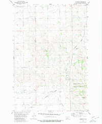
1980 Map of Lynwood
USGS Topo · Published 1980About this map
Little Heart Flats and the elevated Custer Flats dominate the terrain of this Morton County landscape during the late 1970s. The region is defined by the drainage basins of the North Branch Heart River and the Little Heart River, which carve through the prairie towards the Morton County State Game Management Area in the southeast. Infrastructure for the local agricultural economy is centered on the Burlington Northern railroad line, which connects the community of Lynwood and the rail-dependent Saint Anthony Siding. Social history is anchored by the presence of St Johns Cem, while prominent natural landmarks like Little Heart Butte provide clear orientation points against the broad, level plains. The map illustrates a rural North Dakota territory where land use is split between protected habitat and active transportation corridors.
Find a feature on this map
14 named features on this map. Tap any name to fly to it.
Don’t see what you’re looking for? This feature index may not catch every label — zoom into the map to look around manually.
Map Details
Editions of this 1980 Lynwood Map
This is the sole edition of this map. No revisions or reprints were ever made.
Other maps of this area

1907 · Bismarck
USGS Topo · 1:125,000

1950 · Bismarck
USGS Topo · 1:24,000

1951 · Bismarck
USGS Topo · 1:62,500

1951 · Mandan
USGS Topo · 1:24,000

1954 · Bismarck
USGS Topo · 1:250,000

1958 · Bismarck
USGS Topo · 1:250,000

1962 · Schmidt
USGS Topo · 1:24,000

1962 · Bismarck
USGS Topo · 1:24,000

1962 · Mandan
USGS Topo · 1:24,000

1972 · Crown Butte Lake
USGS Topo · 1:24,000