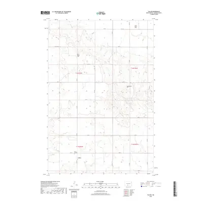
2018 Map of Fallon
USGS Topo · Published 2018About this map
Fallon serves as a central point in this rural landscape within Morton County, where the plains give way to prominent landforms like Oak Coulee Ridge and Rattlesnake Hill. The area is defined by a grid of section roads and cattle-country terrain, with Little Heart Flats occupying the northeast corner of the quadrangle. For those tracing local history or family roots, the map provides the specific location of Saint Peter and Paul Cem, a significant landmark for the community. The township and range boundaries, including t136n r83w and t135n r83w, organize the vast open spaces that characterize this part of North Dakota.
Find a feature on this map
25 named features on this map. Tap any name to fly to it.
Don’t see what you’re looking for? This feature index may not catch every label — zoom into the map to look around manually.
Map Details
Editions of this 2018 Fallon Map
This is the sole edition of this map. No revisions or reprints were ever made.
Other maps of this area

1907 · Bismarck
USGS Topo · 1:125,000

1954 · Bismarck
USGS Topo · 1:250,000

1958 · Bismarck
USGS Topo · 1:250,000

1979 · Bismarck
USGS Topo · 1:100,000

1980 · Breien
USGS Topo · 1:24,000

1980 · Fallon NE
USGS Topo · 1:24,000

1980 · Burgess
USGS Topo · 1:24,000
1980 · Linton
USGS Topo · 1:100,000
1980 · Lynwood
USGS Topo · 1:24,000
1980 · Saint Anthony
USGS Topo · 1:24,000