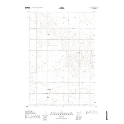
2020 Map of Fallon
USGS Topo · Published 2020About this map
Fallon sits as the central point of interest in this survey of rural Morton County. The settlement and the nearby Saint Peter and Paul Cem represent the community core for this portion of North Dakota. The landscape is defined by its dramatic elevation changes, featuring prominent landmarks like Oak Coulee Ridge and Rattlesnake Hill. This 2020 map documents the grid-like organization of the rural road network, including Co Rd 136 and Co Rd 135, which weave through the townships of t136n r83w and t135n r83w. The survey effectively illustrates the distribution of farmsteads and rural infrastructure across a landscape dominated by coulees and ridges typical of the Missouri Plateau region.
Find a feature on this map
18 named features on this map. Tap any name to fly to it.
Don’t see what you’re looking for? This feature index may not catch every label — zoom into the map to look around manually.
Map Details
Editions of this 2020 Fallon Map
This is the sole edition of this map. No revisions or reprints were ever made.
Other maps of this area

1907 · Bismarck
USGS Topo · 1:125,000

1954 · Bismarck
USGS Topo · 1:250,000

1958 · Bismarck
USGS Topo · 1:250,000

1979 · Bismarck
USGS Topo · 1:100,000

1980 · Breien
USGS Topo · 1:24,000

1980 · Fallon NE
USGS Topo · 1:24,000

1980 · Burgess
USGS Topo · 1:24,000
1980 · Linton
USGS Topo · 1:100,000
1980 · Lynwood
USGS Topo · 1:24,000
1980 · Saint Anthony
USGS Topo · 1:24,000