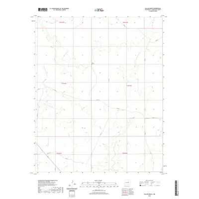
2020 Map of Fallon Ranch
USGS Topo · Published 2020About this map
Arroyo San Juan de Dios and Arroyo Potrillo define the drainage patterns of this high plains landscape in eastern Guadalupe County. The area is characterized by vast open ranges and a network of county roads including Sneed Rd and Werthco Rd. Human presence is sparse, centered on the Fallon Ranch and the isolated Mount Zion Cem near the center of the survey. The mapping reveals the township and range grid system across T6N through T8N, highlighting how the land is partitioned for ranching and public land management. This 2020 data captures the contemporary road network and hydrological features as they existed at the start of the decade, showing how rural infrastructure persists alongside seasonal watercourses in this semi-arid environment.
Find a feature on this map
20 named features on this map. Tap any name to fly to it.
Don’t see what you’re looking for? This feature index may not catch every label — zoom into the map to look around manually.
Map Details
Editions of this 2020 Fallon Ranch Map
This is the sole edition of this map. No revisions or reprints were ever made.
Other maps of this area

1954 · Fort Sumner
USGS Topo · 1:250,000

1958 · Fort Sumner
USGS Topo · 1:250,000

1963 · Sunshine Mesa
USGS Topo · 1:24,000

1963 · Puerto De Luna
USGS Topo · 1:24,000

1964 · Canada Colorado
USGS Topo · 1:24,000

1964 · Fallon Ranch
USGS Topo · 1:24,000
1964 · Salt Lake
USGS Topo · 1:24,000
1964 · Harben Lake
USGS Topo · 1:24,000

1966 · Gibbons Ranch
USGS Topo · 1:24,000

1966 · Ojo Negro Creek
USGS Topo · 1:24,000