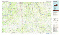
1986 Map of Falmouth
USGS Topo · Published 1986About this map
The Ohio River snakes across the northern reaches of this mid-1980s survey, serving as a corridor for the C & O RR and defining the boundary between Kentucky and Ohio. Inland, the landscape is deeply etched by the Licking River and its South Fork, creating a drainage pattern that dictates the location of historic river towns like Falmouth and Augusta. This area is notable for its unique geological and paleontological history, centered at Big Bone Lick, where the ancient salt lick attracted prehistoric fauna long before the establishment of Big Bone Lick State Park.
Find a feature on this map
81 named features on this map. Tap any name to fly to it.
Don’t see what you’re looking for? This feature index may not catch every label — zoom into the map to look around manually.
Map Details
Editions of this 1986 Falmouth Map
2 editions found
Other maps of this area

1898 · East Cincinnati
USGS Topo · 1:62,500

1906 · Lockport
USGS Topo · 1:48,000

1908 · Lockport
USGS Topo · 1:62,500

1914 · East Cincinnati
USGS Topo · 1:62,500

1914 · West Cincinnati
USGS Topo · 1:62,500

1914 · Batavia
USGS Topo · 1:48,000

1915 · Lawrenceburg
USGS Topo · 1:48,000

1915 · Maysville
USGS Topo · 1:62,500

1916 · Batavia
USGS Topo · 1:62,500

1917 · Sardinia
USGS Topo · 1:62,500