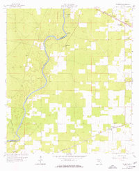
1959 Map of Falmouth
USGS Topo · Published 1977About this map
The Suwannee River snakes along the western edge of this 1950s survey, marking the border between Madison and Suwannee counties. This landscape is defined by its karst topography, with significant hydrologic features like Falmouth Spring and Anderson Spring emerging near the riverbanks. The settlement of Falmouth sits in the northeast corner along the Seaboard Air Line railroad, while Dowling Park and Newburn anchor the southern reaches along the Southern rail line. This period of the late 1950s shows a rural region interconnected by these tracks and a network of country churches, including Mt Gilead Ch and St Johns Ch. Genealogists will find value in the presence of several family-named landmarks and the Stroud Cem, which reflect the established communities situated within the pine woods and scattered depressions of the Florida panhandle.
Find a feature on this map
19 named features on this map. Tap any name to fly to it.
Don’t see what you’re looking for? This feature index may not catch every label — zoom into the map to look around manually.
Map Details
Editions of this 1959 Falmouth Map
3 editions found

Other maps of this area

1954 · Day
USGS Topo · 1:24,000

1954 · Dowling Park
USGS Topo · 1:24,000

1954 · Valdosta
USGS Topo · 1:250,000

1955 · Mayo NE
USGS Topo · 1:24,000

1958 · Valdosta
USGS Topo · 1:250,000

1958 · Fort Union
USGS Topo · 1:24,000

1958 · Madison SE
USGS Topo · 1:24,000

1958 · Lee
USGS Topo · 1:24,000

1959 · Valdosta
USGS Topo · 1:250,000

1959 · Ellaville
USGS Topo · 1:24,000