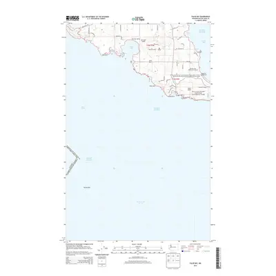
2014 Map of False Bay
USGS Topo · Published 2014About this map
The southern shoreline of San Juan Island defines this coastal landscape, where the rugged maritime boundary between the United States of America and Canada passes through the Puget Sound. The geography is marked by tidal indentations such as False Bay and Kanaka Bay, while the interior terrain rises toward Mt Little. Significant protected acreage is managed within the San Juan Island National Historical Park, which preserves the site of the mid-19th-century boundary dispute between British and American forces. Historical land use and modern utility are visible in the proximity of South Beach to the aviation facilities at Burden Field-(Rabbit Run) Airport. Local access is provided by a network of rural roads like Bailer Hill Rd and Jensen Bay Rd, connecting coastal landmarks from Pile Point in the west to the tranquil waters of Griffin Bay in the east.
Find a feature on this map
45 named features on this map. Tap any name to fly to it.
Don’t see what you’re looking for? This feature index may not catch every label — zoom into the map to look around manually.
Map Details
Editions of this 2014 False Bay Map
This is the sole edition of this map. No revisions or reprints were ever made.
Other maps of this area

1943 · Richardson
USGS Topo · 1:62,500

1943 · Orcas Island
USGS Topo · 1:62,500

1954 · Roche Harbor
USGS Topo · 1:24,000

1954 · Friday Harbor
USGS Topo · 1:24,000

1954 · False Bay
USGS Topo · 1:24,000

1957 · Richardson
USGS Topo · 1:62,500

1957 · Orcas Island
USGS Topo · 1:62,500

1957 · Victoria
USGS Topo · 1:250,000

1973 · Shaw Island
USGS Topo · 1:24,000

1975 · Bellingham
USGS Topo · 1:100,000