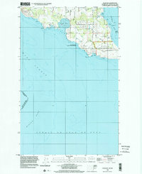
1998 Map of False Bay
USGS Topo · Published 2002About this map
San Juan Island's southern coast comes into focus in this late 1990s record of the maritime landscape and international maritime boundary. The map centers on the distinctive geological indentation of False Bay, characterized by significant sand deposits at low tide, and stretches south across the Middle Bank within the Strait of Juan de Fuca. This area carries deep significance for military and local history, containing the site of the American Campsite and Pickett's Monument within the San Juan Island National Historical Park. The survey illustrates the intersection of conservation and residency, showing the San Juan Islands National Wildlife Refuge alongside local developments like the Mobile Home Park. Coastal features such as Kanaka Bay, Eagle Cove, and the rocky outcroppings of Halftide Rocks define a shoreline that has served as a critical navigation point and military outpost since the mid-19th century.
Find a feature on this map
22 named features on this map. Tap any name to fly to it.
Don’t see what you’re looking for? This feature index may not catch every label — zoom into the map to look around manually.
Map Details
Editions of this 1998 False Bay Map
This is the sole edition of this map. No revisions or reprints were ever made.
Other maps of this area

1943 · Richardson
USGS Topo · 1:62,500

1943 · Orcas Island
USGS Topo · 1:62,500

1954 · Roche Harbor
USGS Topo · 1:24,000

1954 · Friday Harbor
USGS Topo · 1:24,000

1954 · False Bay
USGS Topo · 1:24,000

1957 · Richardson
USGS Topo · 1:62,500

1957 · Orcas Island
USGS Topo · 1:62,500

1957 · Victoria
USGS Topo · 1:250,000

1973 · Shaw Island
USGS Topo · 1:24,000

1975 · Bellingham
USGS Topo · 1:100,000