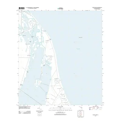
2012 Map of False Cape
USGS Topo · Published 2012About this map
The coastal infrastructure of the Space Age dominates this barrier island landscape along the Atlantic coast of Brevard County. Stretching from Launch Complex 39B in the north to Launch Complex 16 in the south, the map documents a high concentration of launch facilities interspersed with native wetlands and hammocks. This intersection of aerospace technology and Florida's coastal ecology is evident in the proximity of massive engineering projects to areas like Pepper Hammock and Jack Davis Island. Between the ocean and the Banana River, the map records the complex geography of the Merritt Island area, featuring an intricate network of waterways including the Barge Channel and Jack Davis Cut. Named terrain features such as False Cape and Whites Point anchor a landscape defined by its strategic position between the inland lagoons and Chester Shoal in the Atlantic Ocean.
Find a feature on this map
34 named features on this map. Tap any name to fly to it.
Don’t see what you’re looking for? This feature index may not catch every label — zoom into the map to look around manually.
Map Details
Editions of this 2012 False Cape Map
This is the sole edition of this map. No revisions or reprints were ever made.
Other maps of this area

1949 · Orsino
USGS Topo · 1:24,000

1949 · False Cape
USGS Topo · 1:24,000

1949 · Courtenay
USGS Topo · 1:24,000

1949 · Wilson
USGS Topo · 1:24,000

1951 · False Cape
USGS Topo · 1:24,000

1951 · Courtenay
USGS Topo · 1:24,000

1951 · Orsino
USGS Topo · 1:24,000
1951 · Cape Canaveral
USGS Topo · 1:24,000

1952 · Wilson
USGS Topo · 1:24,000

1955 · Orlando
USGS Topo · 1:250,000