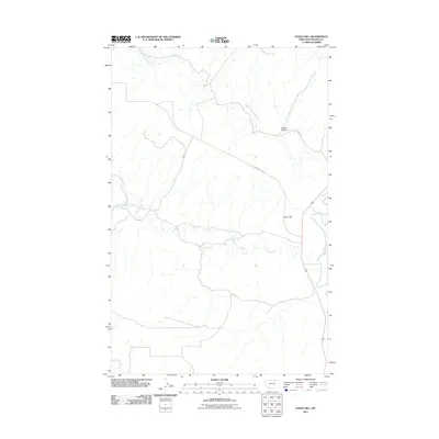
2011 Map of Fanny Hill
USGS Topo · Published 2011About this map
Fanny Hill dominates this portion of the Montana prairie in Phillips County, providing a high point overlooking a network of seasonal and perennial waterways. The prominent Milk River flows through the eastern edge of the quadrangle, serving as the primary drainage for several tributary systems including Cottonwood Creek, Little Cottonwood Creek, and Garland Creek. The landscape is defined by the sharp incisions of prairie coulees, most notably Austin Coulee in the northeast.
Find a feature on this map
7 named features on this map. Tap any name to fly to it.
Don’t see what you’re looking for? This feature index may not catch every label — zoom into the map to look around manually.
Map Details
Editions of this 2011 Fanny Hill Map
This is the sole edition of this map. No revisions or reprints were ever made.
Other maps of this area

1905 · Bowdoin
USGS Topo · 1:62,500

1920 · Cowan
USGS Topo · 1:125,000

1954 · Glasgow
USGS Topo · 1:250,000

1957 · Glasgow
USGS Topo · 1:250,000

1958 · Glasgow
USGS Topo · 1:250,000
1968 · Malta NE
USGS Topo · 1:24,000

1968 · Austin Lake
USGS Topo · 1:24,000

1968 · Hewitt Lake SW
USGS Topo · 1:24,000
1968 · Malta NW
USGS Topo · 1:24,000
1984 · Garland Creek
USGS Topo · 1:24,000