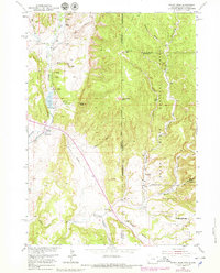
1951 Map of Fanny Peak
USGS Topo · Published 1979About this map
Fanny Peak and Frannie Peak stand as prominent landmarks along the rugged boundary where Wyoming meets South Dakota. This 1951 survey, with revisions from the late 1970s, documents a landscape defined by the Black Hills National Forest and the ranching operations of the L A K Ranch. The terrain is deeply incised by a network of drainage draws and canyons, including Gillette Canyon, Boles Canyon, and Redbird Canyon, which provided critical water sources for local livestock through features like Pease Spring and Roby Spring.
Find a feature on this map
43 named features on this map. Tap any name to fly to it.
Don’t see what you’re looking for? This feature index may not catch every label — zoom into the map to look around manually.
Map Details
Editions of this 1951 Fanny Peak Map
4 editions found
Other maps of this area

1896 · Harney Peak
USGS Topo · 1:125,000

1899 · Newcastle
USGS Topo · 1:125,000

1901 · Harney Peak
USGS Topo · 1:125,000

1901 · Newcastle
USGS Topo · 1:125,000

1951 · Owens
USGS Topo · 1:24,000

1951 · Newcastle
USGS Topo · 1:24,000

1951 · Fanny Peak
USGS Topo · 1:24,000

1951 · Clifton
USGS Topo · 1:24,000

1955 · Dead Horse Flats
USGS Topo · 1:24,000

1955 · Jewel Cave NW
USGS Topo · 1:24,000