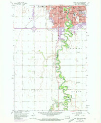
1959 Map of Fargo South
USGS Topo · Published 1973About this map
The Red River of the North carves a winding path between Fargo, North Dakota, and Moorhead, Minnesota, defining the border between Cass Co and Clay Co. This mid-century survey documents the dense institutional landscape of the two cities, highlighting major educational landmarks like Concordia College and the State Teachers College. The urban core is flanked by numerous religious and social institutions, including the Sacred Heart Convent, St Johns Hospital, and the State Childrens Home. South of the primary settlements, the landscape transitions into the agricultural townships of Barnes, Stanley, and Kurtz. The influence of the rail industry is prominent, with the Burlington Northern and the Chicago Milwaukee St Paul and Pacific lines cutting across the plains to support the region's commerce and growth.
Find a feature on this map
50 named features on this map. Tap any name to fly to it.
Don’t see what you’re looking for? This feature index may not catch every label — zoom into the map to look around manually.
Map Details
Editions of this 1959 Fargo South Map
4 editions found
Other maps of this area

1895 · Fargo
USGS Topo · 1:125,000

1897 · Fargo
USGS Topo · 1:125,000

1953 · Fargo
USGS Topo · 1:250,000

1956 · Fargo
USGS Topo · 1:250,000

1959 · Fargo North
USGS Topo · 1:24,000

1959 · South West Fargo
USGS Topo · 1:24,000

1959 · Fargo South
USGS Topo · 1:24,000

1959 · Hickson
USGS Topo · 1:24,000

1959 · West Fargo
USGS Topo · 1:24,000
1959 · Norman
USGS Topo · 1:24,000