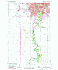
1959 Map of Fargo South
USGS Topo · Published 1977About this map
The Red River of the North winds in sharp oxbows through this mid-century portrait of Fargo, North Dakota, and Moorhead, Minnesota. Based on 1950s surveys with urban revisions into the 1970s, the map reveals a landscape defined by institutional growth and river-based recreation. Educational and social landmarks are prominent, including the State Teachers College, Sacred Heart Convent, and the State Childrens Home. Large-scale public spaces such as Lindenwood Park and the Country Club line the river's banks, while the Burlington Northern and Chicago Milwaukee St Paul and Pacific railroads signal the region's role as a vital transportation hub. Genealogists will find significant value in the numerous burial grounds documented, from Riverside Cemetery and Evergreen Cem in the north to Holy Cross Cem and Salem Ch further south along the river valley.
Find a feature on this map
42 named features on this map. Tap any name to fly to it.
Don’t see what you’re looking for? This feature index may not catch every label — zoom into the map to look around manually.
Map Details
Editions of this 1959 Fargo South Map
4 editions found
Other maps of this area

1895 · Fargo
USGS Topo · 1:125,000

1897 · Fargo
USGS Topo · 1:125,000

1953 · Fargo
USGS Topo · 1:250,000

1956 · Fargo
USGS Topo · 1:250,000

1959 · Fargo North
USGS Topo · 1:24,000

1959 · South West Fargo
USGS Topo · 1:24,000

1959 · Fargo South
USGS Topo · 1:24,000

1959 · Hickson
USGS Topo · 1:24,000

1959 · West Fargo
USGS Topo · 1:24,000
1959 · Norman
USGS Topo · 1:24,000