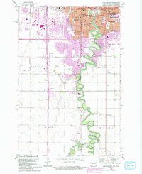
1959 Map of Fargo South
USGS Topo · Published 1993About this map
The Red River of the North carves a serpentine boundary between Fargo, North Dakota, and Moorhead, Minnesota, as they appeared during the late 1950s. This survey records the dense concentration of civic and educational institutions defining the urban core, including Concordia College, the State Teachers College, and numerous parochial and public schools like St Anthony Padua Sch and Agassiz Sch. The landscape reflects a mid-century city expanding southward, where the river's floodplains meet agricultural tracts in Barnes Twp and Stanley.
Find a feature on this map
45 named features on this map. Tap any name to fly to it.
Don’t see what you’re looking for? This feature index may not catch every label — zoom into the map to look around manually.
Map Details
Editions of this 1959 Fargo South Map
4 editions found
Other maps of this area

1895 · Fargo
USGS Topo · 1:125,000

1897 · Fargo
USGS Topo · 1:125,000

1953 · Fargo
USGS Topo · 1:250,000

1956 · Fargo
USGS Topo · 1:250,000

1959 · Fargo North
USGS Topo · 1:24,000

1959 · South West Fargo
USGS Topo · 1:24,000

1959 · Fargo South
USGS Topo · 1:24,000

1959 · Hickson
USGS Topo · 1:24,000

1959 · West Fargo
USGS Topo · 1:24,000
1959 · Norman
USGS Topo · 1:24,000