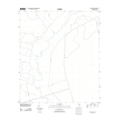
2012 Map of Fargo SW
USGS Topo · Published 2012About this map
The Suwannee River carves a winding path through this portion of Hamilton County, defining the rural character of the North Florida landscape. Near the settlement of Watson, a network of country lanes and state roads like Creek Hwy and Woodpecker Rd connect isolated homesteads and timber tracts. The drainage system is further defined by tributaries such as Rocky Cr and Toms Cr, which feed into the main river channel as it snakes south toward the Gulf. This 2012 digital survey illustrates the persistent rurality of the region, where family-named routes like H Sirmans Ln and Carter Rd hint at long-standing local landownership and the community's connection to the cypress-heavy wetlands of the Florida-Georgia borderlands.
Find a feature on this map
13 named features on this map. Tap any name to fly to it.
Don’t see what you’re looking for? This feature index may not catch every label — zoom into the map to look around manually.
Map Details
Editions of this 2012 Fargo SW Map
This is the sole edition of this map. No revisions or reprints were ever made.
Other maps of this area

1954 · Valdosta
USGS Topo · 1:250,000

1955 · Council
USGS Topo · 1:24,000

1955 · Cypress Creek
USGS Topo · 1:24,000

1955 · Fargo SW
USGS Topo · 1:24,000

1958 · Valdosta
USGS Topo · 1:250,000

1959 · Valdosta
USGS Topo · 1:250,000

1962 · Genoa
USGS Topo · 1:24,000

1967 · Fargo
USGS Topo · 1:24,000

1968 · Needmore
USGS Topo · 1:24,000
1969 · Benton
USGS Topo · 1:24,000