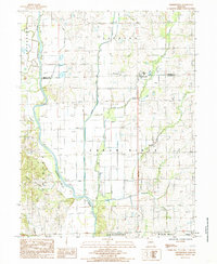
1984 Map of Farmersville
USGS Topo · Published 1985About this map
The Thompson River winds through the western portion of this Missouri landscape, defining the low-lying terrain alongside Jackson Creek. This 1984 survey reveals a highly managed floodplain, where extensive Levee systems protect the surrounding fields and small settlements such as Farmersville and Williams. The area is characterized by its agricultural focus and intricate drainage network, including Honey Creek and Crooked Creek, which feed into the primary river valley.
Find a feature on this map
17 named features on this map. Tap any name to fly to it.
Don’t see what you’re looking for? This feature index may not catch every label — zoom into the map to look around manually.
Map Details
Editions of this 1984 Farmersville Map
This is the sole edition of this map. No revisions or reprints were ever made.
Other maps of this area

1921 · Chillicothe
USGS Topo · 1:62,500

1923 · Chillicothe
USGS Topo · 1:62,500

1924 · Chula
USGS Topo · 1:62,500

1946 · Galt
USGS Topo · 1:62,500

1947 · Chula
USGS Topo · 1:62,500

1948 · Trenton
USGS Topo · 1:62,500

1949 · Galt
USGS Topo · 1:62,500

1953 · Moberly
USGS Topo · 1:250,000

1954 · Centerville
USGS Topo · 1:250,000

1954 · Moberly
USGS Topo · 1:250,000