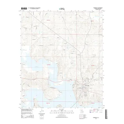
2015 Map of Farmerville
USGS Topo · Published 2015About this map
Farmerville serves as the focal point of this Union Parish survey, situated at a crossroads of North Louisiana's intricate waterway network. The landscape is defined by the sprawling Bayou D'Arbonne Lake, which dominates the western and southern reaches of the quadrangle. Numerous creek systems, including Fourmile Cr, Boatwright Cr, and Bayou de Loutre, carve through the terrain, illustrating the region's historical reliance on these drainages for movement and settlement. Several family and community burial sites are preserved across the area, such as Rabun Cem, Pearson Cem, and Zion Hill Cem, providing vital reference points for genealogical research. The road network, with names like Zion Hill Church Rd and Webster Bluff Rd, reveals the established rural connections between the central township and the surrounding forests and lakefront landings like Platts Lndg.
Find a feature on this map
116 named features on this map. Tap any name to fly to it.
Don’t see what you’re looking for? This feature index may not catch every label — zoom into the map to look around manually.
Map Details
Editions of this 2015 Farmerville Map
This is the sole edition of this map. No revisions or reprints were ever made.
Other maps of this area

1950 · Ruston
USGS Topo · 1:62,500

1951 · Ruston
USGS Topo · 1:62,500

1951 · Bernice
USGS Topo · 1:62,500

1952 · Calhoun
USGS Topo · 1:62,500

1952 · Farmerville
USGS Topo · 1:62,500

1955 · Shreveport
USGS Topo · 1:250,000

1956 · Shreveport
USGS Topo · 1:250,000
1982 · Point
USGS Topo · 1:24,000
1982 · Downsville North
USGS Topo · 1:24,000

1984 · Shreveport
USGS Topo · 1:250,000